shelfmark: Maps C.21.c.9 License: Public Domain 宝永5 *手彩色。元禄元年刊図を改正改刻したもの。書き入れ「江州蒲生郡日野仁正寺 徳井丈達所持」。 Xylograph. Beans 20 & A.12 Uploaded by autobot. Depicts: 1708 Last modified over 6 years ago. Unrectified.
Tags
Links: Source / Biblio Ref |
|
|
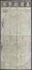
万国総界図 Bankoku sokaizu Map of the entire world
shelfmark: Maps C.21.c.9 License: Public Domain 宝永5 *手彩色。元禄元年刊図を改正改刻したもの。書き入れ「江州蒲生郡日野仁正寺 徳井丈達所持」。 Xylograph. Beans 20 & A.12 Uploaded by autobot. Depicts: 1708 Last modified over 6 years ago. Unrectified. Tags Links: Source / Biblio Ref | |
Title
万国総界図 Bankoku sokaizu [Map of the entire world]
Description
shelfmark: Maps C.21.c.9
License: Public Domain
宝永5 *手彩色。元禄元年刊図を改正改刻したもの。書き入れ「江州蒲生郡日野仁正寺 徳井丈達所持」。 Xylograph. Beans 20 & A.12
Tags:
is_map
Source / Bibliographic Ref URL
https://www.bl.uk/
Publisher
須原茂兵衛 Published in 1708 by Subara[ya] Mohei of Edo.
Author(s)
石川流宣著 Ishikawa Tomonobu (ca. 1661-ca. 1721)
Scale
Published Date
Reprint Date
 WMS Capabilities URL
 Tiles (Google/OSM scheme)
 Download control points as CSV