Browse Maps
| map | Title | Year | Last Updated | Status  |
|---|---|---|---|---|
|
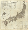
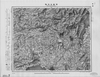
【Courtesy of the C. V. Starr East Asian Library University of California, Berkeley】 1 map : col. ; 46 x 65 cm., folded in cover 22 x 15 cm. Mounted cover title. Copperplate print. In Japanese and English. Oriented with north to the upper right. Relief shown by hachures. 9 insets: Chosenkoku no seisaihyo.--Hokkaido juichikakoku.--Ryukyu, Ogasawara Shoto.--Chishima ... ... et al.. Includes views of points of interest and charts of mountains, rivers and lakes, district names and flags. Includes distance charts, preface and legend. East Asian Library call number: Cb97.
Links: Source / Biblio Ref
|
1887 | over 3 years ago | 5 control points |
|
この地図の作成に当たっては、国土地理院長の承認を得て、同院発行の20万分の1地勢図及び5万分の1地形図を使用した。(承認番号 平30情使、 第1148号)
Links: Source / Biblio Ref
|
1948 | almost 5 years ago | 4 control points |
|
Image from the Map Collections courtesy Stanford University Libraries, licensed under a Creative Commons Attribution-Noncommercial 3.0 Unported License. © Stanford University. 【図幅名】 出水 【測量時期】 明治34年測圖/昭和7年要部修正測圖/昭和10年部分修正測圖 【発行時期】 【記号】 八代十二号 【測量機関】 参謀本部 【備考】 祕
Links: Source / Biblio Ref
|
over 5 years ago | 4 control points | |

|
test
|
2019 | about 5 years ago | 3 control points |
|
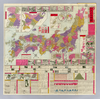
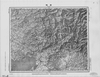
【Courtesy of the C. V. Starr East Asian Library University of California, Berkeley】 1 map : col. ; 153 x 142 cm., folded in cover 27 x 20 cm. Mounted cover title. Copperplate print. In Japanese. Relief shown by hachures. 5 insets: Tokyo zenzu ; Hokkaido zenzu ; Kyoto zenzu ; Osumi Oshima oyobi Ryukyu Shoto ; Ogasawara Gunto. Includes preface and legend. East Asian Library call number: Cb74.
Links: Source / Biblio Ref
|
1881 | over 3 years ago | 5 control points |
|
GISDay2019 Mapwarper
TEST 01
|
2019 | about 5 years ago | 3 control points |
|
(In 1 layer)
Links: Source / Biblio Ref
|
2020 | about 3 years ago | 12 control points |
|
立命館ARC 成立・出版年: 文化10 出版地: 京都
|
2019 | about 5 years ago | 3 control points |
|
Image from the Map Collections courtesy Stanford University Libraries, licensed under a Creative Commons Attribution-Noncommercial 3.0 Unported License. © Stanford University. 【図幅名】 石狩金山 【測量時期】 大正8年測圖 【発行時期】 【記号】 夕張岳十号 【測量機関】 参謀本部 【備考】 祕 (In 1 layer)
Links: Source / Biblio Ref
|
about 2 years ago | 4 control points | |
|
【最初期発行】 この地図の作成に当たっては、国土地理院長の承認を得て、同院発行の20万分の1地勢図及び5万分の1地形図を使用した。(承認番号 平30情使、 第1148号)
Links: Source / Biblio Ref
|
1934 | over 5 years ago | 4 control points |
|
Image from the Map Collections courtesy Stanford University Libraries, licensed under a Creative Commons Attribution-Noncommercial 3.0 Unported License. © Stanford University. 【図幅名】 今金 【測量時期】 大正6年測圖/昭和8年鐡道補入 【発行時期】 【記号】 室蘭十四号 【測量機関】 参謀本部 【備考】 祕 (In 1 layer)
Links: Source / Biblio Ref
|
about 2 years ago | 4 control points | |
|
Image from the Map Collections courtesy Stanford University Libraries, licensed under a Creative Commons Attribution-Noncommercial 3.0 Unported License. © Stanford University. 【図幅名】 須坂 【測量時期】 大正1年測図/昭和12年第2回修正 【発行時期】 昭和21年12月発行 【記号】 長野9号(共16面) 【測量機関】 内務省地理調査所 【備考】
Links: Source / Biblio Ref
|
about 2 years ago | 4 control points | |
|
Image from the Map Collections courtesy Stanford University Libraries, licensed under a Creative Commons Attribution-Noncommercial 3.0 Unported License. © Stanford University. 【図幅名】 太宰府 【測量時期】 明治33年測圖之縮圖/昭和11年修正測圖及第二回修正測圖並修正測圖之縮圖 【発行時期】 【記号】 小倉七号 【測量機関】 参謀本部 【備考】 祕
Links: Source / Biblio Ref
|
about 4 years ago | 4 control points | |
|
【最初期発行】 この地図の作成に当たっては、国土地理院長の承認を得て、同院発行の20万分の1地勢図及び5万分の1地形図を使用した。(承認番号 平30情使、 第1148号)
Links: Source / Biblio Ref
|
1934 | over 5 years ago | 4 control points |
|
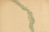
【Courtesy of the C. V. Starr East Asian Library University of California, Berkeley】 1 map : col. ; 115 x 74 cm., folded in cover 21 x 21 cm. In Japanese. Relief shown by ontours and spot heights. 2 insets: Izu Shichito ; Ogasawarajima. Includes legend. East Asian Library call number: Cb98.1.
Links: Source / Biblio Ref
|
1887 | over 3 years ago | 4 control points |
|
【最初期発行】 この地図の作成に当たっては、国土地理院長の承認を得て、同院発行の20万分の1地勢図及び5万分の1地形図を使用した。(承認番号 平30情使、 第1148号)
Links: Source / Biblio Ref
|
1910 | over 5 years ago | 4 control points |
|
【Courtesy of the C. V. Starr East Asian Library University of California, Berkeley】 1 map : col. ; 77 x 75 cm., folded in cover 23 x 16 cm. Mounted cover title. Copperplate print. In Japanese, English and romanized Japanese. Relief shown by hachures. Includes 1 inset and legend. East Asian Library call number: D8.
Links: Source / Biblio Ref
|
1883 | over 3 years ago | 4 control points |
|
【最初期発行】 この地図の作成に当たっては、国土地理院長の承認を得て、同院発行の20万分の1地勢図及び5万分の1地形図を使用した。(承認番号 平30情使、 第1148号)
Links: Source / Biblio Ref
|
1918 | over 5 years ago | 4 control points |
|
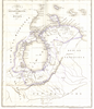
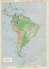
【Courtesy of the C. V. Starr East Asian Library University of California, Berkeley】 Colored manuscript map. Oriented with north toward right. Covers Kyushu, Shikoku and part of Honshu. East Asian Library call number: MJ11.
Links: Source / Biblio Ref
|
1874 | over 3 years ago | 5 control points |
|
【最初期発行】 この地図の作成に当たっては、国土地理院長の承認を得て、同院発行の20万分の1地勢図及び5万分の1地形図を使用した。(承認番号 平30情使、 第1148号) (In 1 layer)
Links: Source / Biblio Ref
|
1904 | almost 4 years ago | 4 control points |
|
【Courtesy of the C. V. Starr East Asian Library University of California, Berkeley】 Colored manuscript map. Oriented with north toward right. Includes compass rose, legend and text. East Asian Library call number: MJ11.
Links: Source / Biblio Ref
|
1874 | over 3 years ago | 5 control points |
|
【最初期発行】 この地図の作成に当たっては、国土地理院長の承認を得て、同院発行の20万分の1地勢図及び5万分の1地形図を使用した。(承認番号 平30情使、 第1148号)
Links: Source / Biblio Ref
|
1916 | over 5 years ago | 4 control points |
|
Image from the Map Collections courtesy Stanford University Libraries, licensed under a Creative Commons Attribution-Noncommercial 3.0 Unported License. © Stanford University. 【図幅名】 下下方 【測量時期】 大正8年測圖/昭和3年鐡道補入 【発行時期】 【記号】 浦河十号 【測量機関】 参謀本部 【備考】 祕 (In 1 layer)
Links: Source / Biblio Ref
|
about 2 years ago | 4 control points | |
|
【最初期発行】 この地図の作成に当たっては、国土地理院長の承認を得て、同院発行の20万分の1地勢図及び5万分の1地形図を使用した。(承認番号 平30情使、 第1148号)
Links: Source / Biblio Ref
|
1928 | over 5 years ago | 4 control points |
|
Mounted cover title.
Wood block print.
Oriented with north to the left.
In Japanese.
Relief shown pictorially.
Includes legend.
Links: Source / Biblio Ref
|
2018 | over 6 years ago | 3 control points |
|
【最初期発行】 この地図の作成に当たっては、国土地理院長の承認を得て、同院発行の20万分の1地勢図及び5万分の1地形図を使用した。(承認番号 平30情使、 第1148号)
Links: Source / Biblio Ref
|
1919 | over 2 years ago | 4 control points |
|
Image from the Map Collections courtesy Stanford University Libraries, licensed under a Creative Commons Attribution-Noncommercial 3.0 Unported License. © Stanford University. 【図幅名】 知来別 【測量時期】 大正12年測図 【発行時期】 大正14年2月発行 【記号】 聲問近傍1号(共7面) 【測量機関】 陸地測量部・参謀本部 【備考】 宗谷4号東部(共7面) 仮製版 軍事極秘
Links: Source / Biblio Ref
|
about 2 years ago | 4 control points | |
|
【最初期発行】 この地図の作成に当たっては、国土地理院長の承認を得て、同院発行の20万分の1地勢図及び5万分の1地形図を使用した。(承認番号 平30情使、 第1148号)
Links: Source / Biblio Ref
|
1917 | about 2 years ago | 4 control points |
|
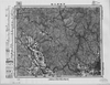
Image from the Map Collections courtesy Stanford University Libraries, licensed under a Creative Commons Attribution-Noncommercial 3.0 Unported License. © Stanford University. 【図幅名】 寒霞渓 【測量時期】 明治30年測図/大正12年測図/大正13年修正 【発行時期】 昭和6年11月発行 【記号】 徳島9号(共14面) 【測量機関】 大日本帝国陸地測量部 【備考】
Links: Source / Biblio Ref
|
about 2 years ago | 4 control points | |
|
【最初期発行】 この地図の作成に当たっては、国土地理院長の承認を得て、同院発行の20万分の1地勢図及び5万分の1地形図を使用した。(承認番号 平30情使、 第1148号)
Links: Source / Biblio Ref
|
1929 | over 5 years ago | 4 control points |
|
Image from the Map Collections courtesy Stanford University Libraries, licensed under a Creative Commons Attribution-Noncommercial 3.0 Unported License. © Stanford University. 【図幅名】 中標津 【測量時期】 大正13年測圖/昭和7年鐡道補入 【発行時期】 【記号】 斜里三号 【測量機関】 参謀本部 【備考】 祕 假製版 (In 1 layer)
Links: Source / Biblio Ref
|
about 2 years ago | 4 control points | |
|
【最初期発行】 この地図の作成に当たっては、国土地理院長の承認を得て、同院発行の20万分の1地勢図及び5万分の1地形図を使用した。(承認番号 平30情使、 第1148号) (In 1 layer)
Links: Source / Biblio Ref
|
1921 | about 2 years ago | 4 control points |
|
Image from the Map Collections courtesy Stanford University Libraries, licensed under a Creative Commons Attribution-Noncommercial 3.0 Unported License. © Stanford University. 【図幅名】 仁木 【測量時期】 大正6年測圖 【発行時期】 【記号】 岩内二号 【測量機関】 参謀本部 【備考】 祕 (In 1 layer)
Links: Source / Biblio Ref
|
about 2 years ago | 4 control points | |
|
|
2019 | over 5 years ago | 4 control points |
|
|
2022 | over 1 year ago | 10 control points |
|
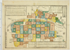
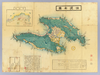
Owned by 立命館大学アート・リサーチセンター 【成立・出版年】 明治12
Links: Source / Biblio Ref
|
1879 | over 5 years ago | 8 control points |
|
【Courtesy of the C. V. Starr East Asian Library University of California, Berkeley】 1 map : col. ; 72 x 98 cm., folded to 24 x 17 cm. Wood block print. In Japanese. Oriented with north to the lower left. Relief shown pictorially. Shows distance of roads and sea routes. Includes 1 inset, preface and legend. East Asian Library call number: D204.
Links: Source / Biblio Ref
|
1876 | over 3 years ago | 4 control points |
|
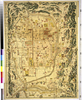
Owned by 立命館大学アート・リサーチセンター 【成立・出版年】 嘉永071854
Links: Source / Biblio Ref
|
1854 | over 5 years ago | 18 control points |
|
Links: Source / Biblio Ref
|
2021 | about 3 years ago | 9 control points |
|
|
2019 | over 5 years ago | 4 control points |
|
Links: Source / Biblio Ref
|
2020 | over 2 years ago | 5 control points |
|
【最初期発行】 この地図の作成に当たっては、国土地理院長の承認を得て、同院発行の20万分の1地勢図及び5万分の1地形図を使用した。(承認番号 平30情使、 第1148号) (In 1 layer)
Links: Source / Biblio Ref
|
1904 | almost 4 years ago | 4 control points |
|
Links: Source / Biblio Ref
|
2020 | over 2 years ago | 4 control points |
|
【最初期発行】 この地図の作成に当たっては、国土地理院長の承認を得て、同院発行の20万分の1地勢図及び5万分の1地形図を使用した。(承認番号 平30情使、 第1148号) (In 1 layer)
Links: Source / Biblio Ref
|
1910 | about 2 years ago | 4 control points |
|
Image from the Map Collections courtesy Stanford University Libraries, licensed under a Creative Commons Attribution-Noncommercial 3.0 Unported License. © Stanford University. 【図幅名】 上足寄 【測量時期】 大正9年測圖 【発行時期】 【記号】 陸別四号 【測量機関】 参謀本部 【備考】 祕 (In 1 layer)
Links: Source / Biblio Ref
|
about 2 years ago | 4 control points | |
|
【最初期発行】 この地図の作成に当たっては、国土地理院長の承認を得て、同院発行の20万分の1地勢図及び5万分の1地形図を使用した。(承認番号 平30情使、 第1148号) (In 1 layer)
Links: Source / Biblio Ref
|
1920 | almost 4 years ago | 4 control points |
|
Image from the Map Collections courtesy Stanford University Libraries, licensed under a Creative Commons Attribution-Noncommercial 3.0 Unported License. © Stanford University. 【図幅名】 稚内 【測量時期】 大正12年測図/昭和3年測図、昭和4年鉄道補入 【発行時期】 昭和21年10月発行 【記号】 宗谷8号(共4面) 【測量機関】 内務省地理調査所 【備考】 (In 1 layer)
Links: Source / Biblio Ref
|
about 2 years ago | 4 control points | |

|
|
2019 | over 5 years ago | 4 control points |
|
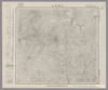
Image from the Map Collections courtesy Stanford University Libraries, licensed under a Creative Commons Attribution-Noncommercial 3.0 Unported License. © Stanford University. 【図幅名】 富高 【測量時期】 明治35年測圖/昭和7年要部修正測圖 【発行時期】 昭和10年発行 【記号】 延岡六号 【測量機関】 大日本帝國陸地測量部 【備考】
Links: Source / Biblio Ref
|
about 4 years ago | 4 control points | |
|
|
2019 | over 5 years ago | 5 control points |