地図を見る
| 地図 | タイトル | 年 | 前回の更新 | ステータス  |
|---|---|---|---|---|
|
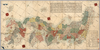
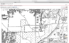
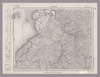
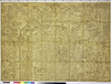
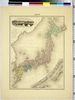
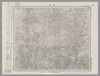
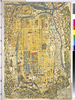
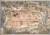
【Courtesy of the C. V. Starr East Asian Library University of California, Berkeley】 Japanese date Meiji 25 1892. In color. Folded. Cover title. Copperplate print. In Japanese. Oriented with north to the upper right. Relief shown by hachures. 13 insets: Hokkaidō no zu.--Chōsenkoku chizu.--Ryūkyū Shotō ... et al. Includes list of prefectures, distance charts, and legend. Title on map: Dai Nihon shinchizu. Includes 1 ancillary map: Sekai no zu.
リンク: 出所・参照情報
|
1892 | 3年以上 前 | 5個の基準点 |
|
リンク: 出所・参照情報
|
2020 | 1年以上 前 | 5個の基準点 |
|
リンク: 出所・参照情報
|
2020 | 約1年 前 | 5個の基準点 |
|
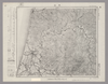
Image from the Map Collections courtesy Stanford University Libraries, licensed under a Creative Commons Attribution-Noncommercial 3.0 Unported License. © Stanford University. 【図幅名】 水津 【測量時期】 大正2年測図/昭和9年修正/昭和28年応急修正 【発行時期】 昭和32年5月発行 【記号】 相川8号(共3面) 【測量機関】 国土地理院 【備考】 応急修正版
リンク: 出所・参照情報
|
約2年 前 | 4個の基準点 | |
|
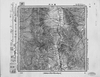
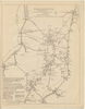
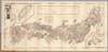
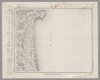
【Courtesy of the C. V. Starr East Asian Library University of California, Berkeley】 Japanese date Kaei 2 1849. In color. Folded. Wood block print. In Japanese. Oriented with north to the upper right. Covers Matsumae to Tsushima and Ryūkyū. Title from: Nihon chizushi / Akioka Takejirō. p.152. Shows longitudes and latitudes and Kuroshio. Includes distance chart and legend. Shows distances of the sea routes. Title on library's envelope.
リンク: 出所・参照情報
|
1849 | 3年以上 前 | 5個の基準点 |
|
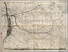
Image from the Map Collections courtesy Stanford University Libraries, licensed under a Creative Commons Attribution-Noncommercial 3.0 Unported License. © Stanford University. 【図幅名】 本荘 【測量時期】 大正2年測図/大正14年鉄道補入 【発行時期】 大正15年11月発行 【記号】 秋田16号(共16面) 【測量機関】 大日本帝国陸地測量部 【備考】
リンク: 出所・参照情報
|
5年以上 前 | 4個の基準点 | |
|
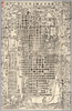
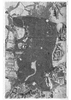
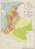
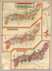
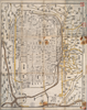
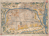
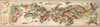
【Courtesy of the C. V. Starr East Asian Library University of California, Berkeley】 Japanese date Genroku 3 1690 estimated. Folded. Mounted cover title. Wood block print. In Japanese. Relief shown pictorially. Includes index. Title on map :Shinpan Heianjō narabini Rakugai no zu. Copyright by Honʼya Riemon.
リンク: 出所・参照情報
|
1690 | 3年以上 前 | 4個の基準点 |
|
リンク: 出所・参照情報
|
2021 | 約3年 前 | 4個の基準点 |
|
リンク: 出所・参照情報
|
2020 | 約1年 前 | 3個の基準点 |
|
|
2020 | 3年以上 前 | 3個の基準点 |
|
リンク: 出所・参照情報
|
2020 | 約1年 前 | 4個の基準点 |
|
|
2020 | 3年以上 前 | 7個の基準点 |
|
|
2019 | 4年以上 前 | 3個の基準点 |
|
この地図の作成に当たっては、国土地理院長の承認を得て、同院発行の20万分の1地勢図及び5万分の1地形図を使用した。(承認番号 平30情使、 第1148号)
リンク: 出所・参照情報
|
1946 | 5年以上 前 | 4個の基準点 |

|
test
|
2020 | 3年以上 前 | 4個の基準点 |
|
|
2020 | 3年以上 前 | 94個の基準点 |
|
この地図の作成に当たっては、国土地理院長の承認を得て、同院発行の20万分の1地勢図及び5万分の1地形図を使用した。(承認番号 平30情使、 第1148号)
リンク: 出所・参照情報
|
1947 | 5年以上 前 | 4個の基準点 |
|
Image from the Map Collections courtesy Stanford University Libraries, licensed under a Creative Commons Attribution-Noncommercial 3.0 Unported License. © Stanford University. 【図幅名】 日奈久 【測量時期】 明治34年測圖/大正15年修正測圖/昭和7年部分修正測圖 【発行時期】 【記号】 八代六号 【測量機関】 参謀本部 【備考】 祕
リンク: 出所・参照情報
|
5年以上 前 | 4個の基準点 | |
|
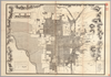
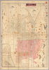
【Courtesy of the C. V. Starr East Asian Library University of California, Berkeley】 Japanese date Meiji 36 1903. Folded. Title on envelope: Eibun Kyōto jissoku shinchizu = Kyoto new atlas. In Japanese and English. Oriented with north to the upper right. Relief shown by hachures. Includes legend.
リンク: 出所・参照情報
|
1903 | 3年以上 前 | 4個の基準点 |
|
リンク: 出所・参照情報
|
2020 | 1年以上 前 | 20個の基準点 |
|
|
2020 | 3年以上 前 | 4個の基準点 |
|
|
1741 | 約4年 前 | 9個の基準点 |
|
|
2023 | 11ヶ月 前 | 8個の基準点 |
|
リンク: 出所・参照情報
|
2020 | 約1年 前 | 10個の基準点 |
|
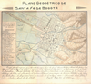
【Courtesy of the C. V. Starr East Asian Library University of California, Berkeley】 Japanese date Meiji 34 1901. In color. Folded. Lithograph. In Japanese. Relief shown by hachures and pictorially. 2 insets: Kyōto-fu Yamashiro Fushimi-chō; Shiga-ken Ōmi Ōtsu-shi. Includes legend.
リンク: 出所・参照情報
|
1901 | 3年以上 前 | 4個の基準点 |
|
|
2018 | 5年以上 前 | 11個の基準点 |
|
|
2022 | 1年以上 前 | 10個の基準点 |
|
Image from the Map Collections courtesy Stanford University Libraries, licensed under a Creative Commons Attribution-Noncommercial 3.0 Unported License. © Stanford University. 【図幅名】 乗鞍岳 【測量時期】 大正1年測図/昭和5年修正/昭和6年部分修正 【発行時期】 昭和8年3月発行 【記号】 高山8号(共16面) 【測量機関】 大日本帝国陸地測量部 【備考】
リンク: 出所・参照情報
|
約2年 前 | 4個の基準点 | |
|
【Courtesy of the C. V. Starr East Asian Library University of California, Berkeley】 Japanese date Meiji 43 1910. In color. Folded. In Japanese Oriented with north to the left. Relief shown by hachures. 6 insets: Kyōto-fu Kan̕nai chizu.--Kyōto fukin meishō chizu.--Takao oyobi Saga Hozu meishō chizu.--Nara shigai zenzu.--Ōtsu shigai zenzu.--Hieizan fukinzu. Includes distance chart and legend. Includes text views of tourist attractions on verso.
リンク: 出所・参照情報
|
1910 | 3年以上 前 | 4個の基準点 |
|
この地図の作成に当たっては、国土地理院長の承認を得て、同院発行の20万分の1地勢図及び5万分の1地形図を使用した。(承認番号 平30情使、 第1148号)
リンク: 出所・参照情報
|
1946 | 5年以上 前 | 4個の基準点 |
|
【Courtesy of the C. V. Starr East Asian Library University of California, Berkeley】 Japanese date Jokyo 4 1687 estimated. In color. Folded. Wood block print. In Japanese. Title added by hand. Relief shown pictorially. Includes distance chart and index
リンク: 出所・参照情報
|
1687 | 3年以上 前 | 4個の基準点 |
|
Image from the Map Collections courtesy Stanford University Libraries, licensed under a Creative Commons Attribution-Noncommercial 3.0 Unported License. © Stanford University. 【図幅名】 小諸 【測量時期】 大正1年測図/昭和4年修正 【発行時期】 【記号】 長野11号 【測量機関】 参謀本部 【備考】 秘
リンク: 出所・参照情報
|
約2年 前 | 4個の基準点 | |
|
【Courtesy of the C. V. Starr East Asian Library University of California, Berkeley】 Japanese date Meiji 32 1899. Folded. Copperplate print. In Japanese. Oriented with north to the lower right. Relief shown by hachures. Includes 9 insets: Hokkaidō.--Taiwan zu.--Ryūkyū Chūhokubu Shotō ... et al. Includes views of points of interest, distance chart, and legend. Shows sea routes with distance.
リンク: 出所・参照情報
|
1899 | 3年以上 前 | 5個の基準点 |
|
Image from the Map Collections courtesy Stanford University Libraries, licensed under a Creative Commons Attribution-Noncommercial 3.0 Unported License. © Stanford University. 【図幅名】 追貝 【測量時期】 大正1年測図/昭和33年要部修正 【発行時期】 昭和35年4月発行 【記号】 日光16号 【測量機関】 国土地理院 【備考】
リンク: 出所・参照情報
|
約2年 前 | 4個の基準点 | |
|
【Courtesy of the C. V. Starr East Asian Library University of California, Berkeley】 Japanese date Meiji 31 1898. In color. Folded. In Japanese. Oriented with north to the upper right. Shows distances of roads and sea routes. Includes 4 insets: Taiwan zenzu.--Hokkaidō.--Ogasawarajima Guntō ... et al. Includes legend.
リンク: 出所・参照情報
|
1898 | 3年以上 前 | 5個の基準点 |
|
この地図の作成に当たっては、国土地理院長の承認を得て、同院発行の20万分の1地勢図及び5万分の1地形図を使用した。(承認番号 平30情使、 第1148号)
リンク: 出所・参照情報
|
1946 | 5年以上 前 | 4個の基準点 |
|
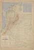
【Courtesy of the C. V. Starr East Asian Library University of California, Berkeley】 Japanese date Meiji 10 1877. In color. Folded. 3 maps on one sheet.Copperplate print. In Japanese. Oriented with north to the upper right. Relief shown by hachures. Contents: Kokugun kubunzu ; Fuken kankatsu saibansho kukaizu ; Zenkoku chimei sansen meisaizu. 2 insets: Ryūkyū Shotō zu ; Ogasawara zentō zu. 1 ancillary map: Hokkaidō oyobi Chishima Zentō zu. Includes charts of mountains and rivers , preface and legend.
リンク: 出所・参照情報
|
1877 | 3年以上 前 | 4個の基準点 |
|
【Courtesy of the C. V. Starr East Asian Library University of California, Berkeley】 Mounted cover title. Wood block print. In Japanese. Shows distance.
リンク: 出所・参照情報
|
1751 | 3年以上 前 | 4個の基準点 |
|
リンク: 出所・参照情報
|
2020 | 約1年 前 | 5個の基準点 |
|
【Courtesy of the C. V. Starr East Asian Library University of California, Berkeley】 Wood block print. In Japanese. Relief shown pictorially. Oriented with north to the left. Title from Mitsui Map collection in U.C.B.
リンク: 出所・参照情報
|
1850 | 3年以上 前 | 4個の基準点 |

|
リンク: 出所・参照情報
|
2020 | 約1年 前 | 4個の基準点 |
|
【Courtesy of the C. V. Starr East Asian Library University of California, Berkeley】 Col. map.
リンク: 出所・参照情報
|
1895 | 3年以上 前 | 4個の基準点 |
|
【Courtesy of the C. V. Starr East Asian Library University of California, Berkeley】 Japanese date Meiji 19 1886. In color. Folded. Copperplate print. In Japanese. Oriented with north to the upper right. Relief shown by hachures. Shows distances of roads. 3 insets: Hokkaidō ; Ryūkyū Chūhokubu Shotō ; Ryūkyū Nanbu Shotō. Includes legend.
リンク: 出所・参照情報
|
1886 | 3年以上 前 | 5個の基準点 |
|
|
2018 | 6年以上 前 | 4個の基準点 |
|
【Courtesy of the C. V. Starr East Asian Library University of California, Berkeley】 Japanese date Tenmei 7 1787. In color. Folded. Mounted cover title. Wood block print. In Japanese. Oriented with north to the right. Relief shown pictorially. Includes legend. Shows the western part of Lake Biwa.
リンク: 出所・参照情報
|
1878 | 3年以上 前 | 4個の基準点 |
|
Image from the Map Collections courtesy Stanford University Libraries, licensed under a Creative Commons Attribution-Noncommercial 3.0 Unported License. © Stanford University. 【図幅名】 【測量時期】 【発行時期】 【記号】 【測量機関】 【備考】 ( 1枚のレイヤー)
リンク: 出所・参照情報
|
約2年 前 | 4個の基準点 | |
|
【Courtesy of the C. V. Starr East Asian Library University of California, Berkeley】 Japanese date Tenpō 5 1834. In color. Folded. Wood block print. Oriented with north to the left. In Japanese. Relief shown pictorially. Drawn by Nakamura Yūrakusai. Includes legend. Title added by hand.
リンク: 出所・参照情報
|
1834 | 3年以上 前 | 4個の基準点 |
|
Image from the Map Collections courtesy Stanford University Libraries, licensed under a Creative Commons Attribution-Noncommercial 3.0 Unported License. © Stanford University.
リンク: 出所・参照情報
|
約6年 前 | 4個の基準点 | |
|
この地図の作成に当たっては、国土地理院長の承認を得て、同院発行の20万分の1地勢図及び5万分の1地形図を使用した。(承認番号 平30情使、 第1148号)
リンク: 出所・参照情報
|
1953 | 5年以上 前 | 4個の基準点 |
|
Image from the Map Collections courtesy Stanford University Libraries, licensed under a Creative Commons Attribution-Noncommercial 3.0 Unported License. © Stanford University.
リンク: 出所・参照情報
|
約6年 前 | 4個の基準点 |