Browse Maps
| map | Title | Year  |
Last Updated | Status |
|---|---|---|---|---|
|
説明
|
1944 | about 4 years ago | 4 control points |

|
|
1944 | 3 months ago | 4 control points |

|
Links: Source / Biblio Ref
|
1944 | over 6 years ago | 64 control points |
|
50%に縮小
|
1944 | almost 5 years ago | 13 control points |

|
村岡碩市写 肥前一国絵図(元禄)の佐賀県部分模写 彩色手書
Links: Source / Biblio Ref
|
1944 | almost 5 years ago | 4 control points |
|
この地図の作成に当たっては、国土地理院長の承認を得て、同院発行の20万分の1地勢図及び5万分の1地形図を使用した。(承認番号 平30情使、 第1148号)
Links: Source / Biblio Ref
|
1943 | over 5 years ago | 4 control points |
|
この地図の作成に当たっては、国土地理院長の承認を得て、同院発行の20万分の1地勢図及び5万分の1地形図を使用した。(承認番号 平30情使、 第1148号)
Links: Source / Biblio Ref
|
1943 | over 5 years ago | 4 control points |
|
|
1942 | 7 months ago | 3 control points |
|
|
1939 | 8 months ago | 24 control points |
|
|
1938 | about 4 years ago | 4 control points |
|
この地図の作成に当たっては、国土地理院長の承認を得て、同院発行の20万分の1地勢図及び5万分の1地形図を使用した。(承認番号 平30情使、 第1148号)
Links: Source / Biblio Ref
|
1937 | over 5 years ago | 4 control points |
|
この地図の作成に当たっては、国土地理院長の承認を得て、同院発行の20万分の1地勢図及び5万分の1地形図を使用した。(承認番号 平30情使、 第1148号)
Links: Source / Biblio Ref
|
1937 | over 5 years ago | 4 control points |
|
この地図の作成に当たっては、国土地理院長の承認を得て、同院発行の20万分の1地勢図及び5万分の1地形図を使用した。(承認番号 平30情使、 第1148号)
Links: Source / Biblio Ref
|
1936 | over 5 years ago | 4 control points |
|
この地図の作成に当たっては、国土地理院長の承認を得て、同院発行の20万分の1地勢図及び5万分の1地形図を使用した。(承認番号 平30情使、 第1148号)
Links: Source / Biblio Ref
|
1936 | over 5 years ago | 4 control points |
|
この地図の作成に当たっては、国土地理院長の承認を得て、同院発行の20万分の1地勢図及び5万分の1地形図を使用した。(承認番号 平30情使、 第1148号)
Links: Source / Biblio Ref
|
1936 | over 5 years ago | 4 control points |
|
Image from the Map Collections courtesy Stanford University Libraries. This item is in the public domain. There are no restrictions on use.
【図幅名】 劒崎【測量時期】 大正4年測圖 【発行時期】昭和11年 【記号】 千島列島五十一号 【測量機関】 参謀本部 【その他】千島列島 陸地測量部 (In 1 layer)
Links: Source / Biblio Ref
|
1936 | over 1 year ago | 4 control points |
|
Image from the Map Collections courtesy Stanford University Libraries. This item is in the public domain. There are no restrictions on use.
【図幅名】 計吐夷島 【測量時期】 大正6年測圖 【発行時期】昭和11年 【記号】 羅処和島八号、十二号、新知島一号【測量機関】 参謀本部 【その他】千島列島 陸地測量部 (In 1 layer)
Links: Source / Biblio Ref
|
1936 | over 1 year ago | 4 control points |
|
Image from the Map Collections courtesy Stanford University Libraries. This item is in the public domain. There are no restrictions on use.
【図幅名】 新知嶽 【測量時期】 大正5年測圖 【発行時期】昭和11年 【記号】 新知島十二号 【測量機関】 参謀本部 【その他】千島列島 陸地測量部 (In 1 layer)
Links: Source / Biblio Ref
|
1936 | over 1 year ago | 4 control points |
|
Image from the Map Collections courtesy Stanford University Libraries. This item is in the public domain. There are no restrictions on use.
【図幅名】 武魯頓嶋【測量時期】 大正5年測圖 【発行時期】昭和11年 【記号】 千島列島四十七号、知理保以嶋一号西北部 【測量機関】 参謀本部 【その他】千島列島 陸地測量部 (In 1 layer)
Links: Source / Biblio Ref
|
1936 | over 1 year ago | 5 control points |
|
Image from the Map Collections courtesy Stanford University Libraries. This item is in the public domain. There are no restrictions on use.
【図幅名】 三股山【測量時期】 大正4年測圖 【発行時期】昭和11年 【記号】 温禰古丹嶋四号 【測量機関】 参謀本部 【その他】千島列島 陸地測量部
Links: Source / Biblio Ref
|
1936 | over 1 year ago | 4 control points |
|
Image from the Map Collections courtesy Stanford University Libraries. This item is in the public domain. There are no restrictions on use.
【図幅名】 櫛ノ崎【測量時期】 大正4年測圖 【発行時期】昭和11年 【記号】 得撫嶋七号 【測量機関】 参謀本部 【その他】千島列島 陸地測量部 (In 1 layer)
Links: Source / Biblio Ref
|
1936 | over 1 year ago | 4 control points |
|
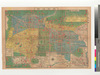
<대경성정도大京城精圖>는 1936년에 경성지성당至誠堂에서 경성부의 교열을 거쳐 발행한 서울지도로서 전체 17장補 4장 포함으로 구성된 지번도이다. 이 지도는 대경성정도 답게 관할 구역이 확장된 후 구획과 지번을 넣어 만든 자세한 지도다. 맨 앞장인 <대경성정도일람도>의 축척은 1:25,000이며, 다른 분도分圖는 1:6,000이다. 지도 순서는 동쪽에서 서쪽으로 편집되어 있으며, 도성내부는 5번 지도에 수록되어 있다.
판권자와 발행인은 반미경평飯米耕平이며, 제도자는 삼전선당森田仙堂이고, 인쇄소는 야진집문당野津集文堂이다.
이 지도가 제작된 1936년은 경성시가지계획과 경성토지구획정리지구가 발표된 해이다. 그러므로 이 지도는 관할 구역이 확장되고 도시계획이 확정되어 근대도시로서 경성의 계획된 면모를 보여주는 자료라고 할 수 있다. 당시 경성은 50만명 정도의 인구가 살도록 계획되었고, 이를 위해 도로가 확장되고, 구불구불한 도로를 직선화하였으며, 새로운 길을 내고, 청계천의 일부를 복개하는 등 도시화가 가속화되었다. 그러나 경복궁과 경희궁의 전각이 다 헐려나가고 창덕궁과 종묘를 잇는 축을 도로를 내기 위해 자르는 등 조선왕실의 전통과 문화를 파괴한 흔적 또한 자세히 볼 수 있다.
이렇게 지번地番을 넣은 서울지도는 이후에도 여러 차례1958 · 1969 · 1986 · 1988 · 1993 등 제작 · 간행되었는데, 모두 이 지도를 모본으로 하여 제작되었다.
Links: Source / Biblio Ref
|
1936 | almost 5 years ago | 3 control points |
|
Image from the Map Collections courtesy Stanford University Libraries. This item is in the public domain. There are no restrictions on use.
【図幅名】 松輪島 【測量時期】 大正6年測圖 【発行時期】昭和11年 【記号】 松輪島十七号 【測量機関】 参謀本部 【その他】千島列島 陸地測量部 (In 1 layer)
Links: Source / Biblio Ref
|
1936 | over 1 year ago | 5 control points |
|
Image from the Map Collections courtesy Stanford University Libraries. This item is in the public domain. There are no restrictions on use.
【図幅名】 磨勘留嶋【測量時期】 大正4年測圖 【発行時期】昭和11年 【記号】 温禰古丹嶋十号 【測量機関】 参謀本部 【その他】千島列島 陸地測量部
Links: Source / Biblio Ref
|
1936 | over 1 year ago | 4 control points |
|
Image from the Map Collections courtesy Stanford University Libraries. This item is in the public domain. There are no restrictions on use.
【図幅名】 知理保以南嶋【測量時期】 大正5年測圖 【発行時期】昭和11年 【記号】 千島列島四十六号 【測量機関】 参謀本部 【その他】千島列島 陸地測量部 (In 1 layer)
Links: Source / Biblio Ref
|
1936 | over 1 year ago | 4 control points |
|
Image from the Map Collections courtesy Stanford University Libraries. This item is in the public domain. There are no restrictions on use.
【図幅名】 根茂山【測量時期】 大正4年測圖 【発行時期】昭和11年 【記号】 捨子古丹島六号 【測量機関】 参謀本部 【その他】千島列島 陸地測量部
Links: Source / Biblio Ref
|
1936 | over 1 year ago | 4 control points |
|
Image from the Map Collections courtesy Stanford University Libraries. This item is in the public domain. There are no restrictions on use.
【図幅名】 ピリカモヘ崎【測量時期】 大正4年測圖 【発行時期】昭和11年 【記号】 千島列島五十七号 【測量機関】 参謀本部 【その他】千島列島 陸地測量部 (In 1 layer)
Links: Source / Biblio Ref
|
1936 | over 1 year ago | 4 control points |
|
Image from the Map Collections courtesy Stanford University Libraries. This item is in the public domain. There are no restrictions on use.
【図幅名】 羅處和島【測量時期】 大正6年測圖 【発行時期】昭和11年 【記号】 羅處和島二号 【測量機関】 参謀本部 【その他】千島列島 陸地測量部 (In 1 layer)
Links: Source / Biblio Ref
|
1936 | over 1 year ago | 4 control points |
|
Image from the Map Collections courtesy Stanford University Libraries. This item is in the public domain. There are no restrictions on use.
【図幅名】 春牟古丹島西部【測量時期】 大正5年測圖 【発行時期】昭和11年 【記号】 捨子古丹島十号 【測量機関】 参謀本部 【その他】千島列島 陸地測量部
Links: Source / Biblio Ref
|
1936 | over 1 year ago | 4 control points |
|
Image from the Map Collections courtesy Stanford University Libraries. This item is in the public domain. There are no restrictions on use.
【図幅名】 知林古丹嶋【測量時期】 大正5年測圖 【発行時期】昭和11年 【記号】 知林古丹嶋十一号 【測量機関】 参謀本部 【その他】千島列島 陸地測量部
Links: Source / Biblio Ref
|
1936 | over 1 year ago | 4 control points |
|
Image from the Map Collections courtesy Stanford University Libraries. This item is in the public domain. There are no restrictions on use.
【図幅名】 白妙山【測量時期】 大正4年測圖 【発行時期】昭和11年 【記号】 千島列島五十八号 【測量機関】 参謀本部 【その他】千島列島 陸地測量部 (In 1 layer)
Links: Source / Biblio Ref
|
1936 | over 1 year ago | 4 control points |
|
Image from the Map Collections courtesy Stanford University Libraries. This item is in the public domain. There are no restrictions on use.
【図幅名】 床丹【測量時期】 大正4年測圖 【発行時期】昭和11年 【記号】 千島列島五十五号 【測量機関】 参謀本部 【その他】千島列島 陸地測量部 (In 1 layer)
Links: Source / Biblio Ref
|
1936 | over 1 year ago | 4 control points |
|
Image from the Map Collections courtesy Stanford University Libraries. This item is in the public domain. There are no restrictions on use.
【図幅名】 知理保以北嶋【測量時期】 大正5年測圖 【発行時期】昭和11年 【記号】 知理保以島一号 【測量機関】 参謀本部 【その他】千島列島 陸地測量部 (In 1 layer)
Links: Source / Biblio Ref
|
1936 | over 1 year ago | 4 control points |
|
Image from the Map Collections courtesy Stanford University Libraries. This item is in the public domain. There are no restrictions on use.
【図幅名】 黒石山【測量時期】 大正4年測圖 【発行時期】昭和11年 【記号】 温禰古丹嶋八号 【測量機関】 参謀本部 【その他】千島列島 陸地測量部
Links: Source / Biblio Ref
|
1936 | over 1 year ago | 4 control points |
|
Links: Source / Biblio Ref
|
1936 | over 3 years ago | 5 control points |
|
Image from the Map Collections courtesy Stanford University Libraries. This item is in the public domain. There are no restrictions on use.
【図幅名】 寶珠山【測量時期】 大正4年測圖 【発行時期】昭和11年 【記号】 捨子古丹島一号 【測量機関】 参謀本部 【その他】千島列島 陸地測量部 (In 1 layer)
Links: Source / Biblio Ref
|
1936 | over 1 year ago | 4 control points |
|
この地図の作成に当たっては、国土地理院長の承認を得て、同院発行の20万分の1地勢図及び5万分の1地形図を使用した。(承認番号 平30情使、 第1148号)
Links: Source / Biblio Ref
|
1936 | over 5 years ago | 4 control points |
|
Image from the Map Collections courtesy Stanford University Libraries. This item is in the public domain. There are no restrictions on use.
【図幅名】 春牟古丹島東部【測量時期】 大正5年測圖 【発行時期】昭和11年 【記号】 捨子古丹島六号 【測量機関】 参謀本部 【その他】千島列島 陸地測量部
Links: Source / Biblio Ref
|
1936 | over 1 year ago | 4 control points |
|
Image from the Map Collections courtesy Stanford University Libraries. This item is in the public domain. There are no restrictions on use.
【図幅名】 雷公計島【測量時期】 大正6年測圖 【発行時期】昭和11年 【記号】 松輪島十五号 【測量機関】 参謀本部 【その他】千島列島 陸地測量部 (In 1 layer)
Links: Source / Biblio Ref
|
1936 | over 1 year ago | 4 control points |
|
Image from the Map Collections courtesy Stanford University Libraries. This item is in the public domain. There are no restrictions on use.
【図幅名】 名古嶋【測量時期】 大正4年測圖 【発行時期】昭和11年 【記号】 千島列島五十四号 【測量機関】 参謀本部 【その他】千島列島 陸地測量部 (In 1 layer)
Links: Source / Biblio Ref
|
1936 | over 1 year ago | 4 control points |
|
【最初期発行】 この地図の作成に当たっては、国土地理院長の承認を得て、同院発行の20万分の1地勢図及び5万分の1地形図を使用した。(承認番号 平30情使、 第1148号)
Links: Source / Biblio Ref
|
1936 | over 2 years ago | 4 control points |
|
Image from the Map Collections courtesy Stanford University Libraries. This item is in the public domain. There are no restrictions on use.
【図幅名】 越渇麿嶋【測量時期】 大正5年測圖 【発行時期】昭和11年 【記号】 知林古丹島三号 【測量機関】 参謀本部 【その他】千島列島 陸地測量部 (In 1 layer)
Links: Source / Biblio Ref
|
1936 | over 1 year ago | 4 control points |
|
Image from the Map Collections courtesy Stanford University Libraries. This item is in the public domain. There are no restrictions on use.
【図幅名】 伽藍崎【測量時期】 大正4年測圖 【発行時期】昭和11年 【記号】 千島列島五十六号 【測量機関】 参謀本部 【その他】千島列島 陸地測量部 (In 1 layer)
Links: Source / Biblio Ref
|
1936 | over 1 year ago | 4 control points |
|
Image from the Map Collections courtesy Stanford University Libraries. This item is in the public domain. There are no restrictions on use.
【図幅名】 末廣嶽 【測量時期】 大正5年測圖 【発行時期】昭和11年 【記号】 新知島七号 【測量機関】 参謀本部 【その他】千島列島 陸地測量部 (In 1 layer)
Links: Source / Biblio Ref
|
1936 | over 1 year ago | 4 control points |
|
Image from the Map Collections courtesy Stanford University Libraries. This item is in the public domain. There are no restrictions on use.
【図幅名】 新知灣 【測量時期】 大正5年測圖 【発行時期】昭和11年 【記号】 新知島十一号 【測量機関】 参謀本部【その他】千島列島 陸地測量部 (In 1 layer)
Links: Source / Biblio Ref
|
1936 | over 1 year ago | 4 control points |
|
Image from the Map Collections courtesy Stanford University Libraries. This item is in the public domain. There are no restrictions on use.
【図幅名】 大三頭山【測量時期】 大正4年測圖 【発行時期】昭和11年 【記号】 千島列島四十九号 【測量機関】 参謀本部 【その他】千島列島 陸地測量部 (In 1 layer)
Links: Source / Biblio Ref
|
1936 | over 1 year ago | 4 control points |
|
Image from the Map Collections courtesy Stanford University Libraries. This item is in the public domain. There are no restrictions on use.
【図幅名】 黑嶽【測量時期】 大正5年測圖 【発行時期】昭和11年 【記号】 捨子古丹島十五号 【測量機関】 参謀本部 【その他】千島列島 陸地測量部 (In 1 layer)
Links: Source / Biblio Ref
|
1936 | over 1 year ago | 4 control points |
|
Image from the Map Collections courtesy Stanford University Libraries. This item is in the public domain. There are no restrictions on use.
【図幅名】 鳥ノ尾崎【測量時期】 大正4年測圖 【発行時期】昭和11年 【記号】 千島列島四十八号 【測量機関】 参謀本部 【その他】千島列島 陸地測量部 (In 1 layer)
Links: Source / Biblio Ref
|
1936 | over 1 year ago | 4 control points |
|
Image from the Map Collections courtesy Stanford University Libraries. This item is in the public domain. There are no restrictions on use.
【図幅名】 伸津崎【測量時期】 大正4年測圖 【発行時期】昭和11年 【記号】 得撫嶋十一号 【測量機関】 参謀本部 【その他】千島列島 陸地測量部 (In 1 layer)
Links: Source / Biblio Ref
|
1936 | over 1 year ago | 4 control points |
|
Image from the Map Collections courtesy Stanford University Libraries. This item is in the public domain. There are no restrictions on use.
【図幅名】 宇志知島【測量時期】 大正6年測圖 【発行時期】昭和11年 【記号】 羅処和島三号 【測量機関】 参謀本部 【その他】千島列島 陸地測量部 (In 1 layer)
Links: Source / Biblio Ref
|
1936 | over 1 year ago | 4 control points |