Browse Maps
| map | Title | Year | Last Updated  |
Status |
|---|---|---|---|---|
|
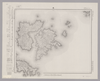
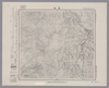
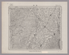
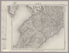
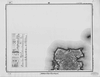
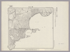
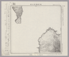
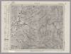
Image from the Map Collections courtesy Stanford University Libraries, licensed under a Creative Commons Attribution-Noncommercial 3.0 Unported License. © Stanford University. 【図幅名】 菱 【測量時期】 大正1年測図/昭和9年修正/昭和28年応急修正 【発行時期】 昭和34年8月発行 【記号】 西郷16号(共4面) 【測量機関】 国土地理院 【備考】 応急修正版
Links: Source / Biblio Ref
|
3 days ago | 4 control points | |
|
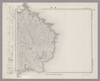
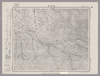
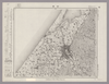
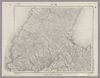
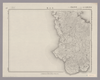
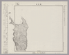
Image from the Map Collections courtesy Stanford University Libraries, licensed under a Creative Commons Attribution-Noncommercial 3.0 Unported License. © Stanford University. 【図幅名】 西郷 【測量時期】 大正元年測圖/昭和9年測圖 【発行時期】 【記号】 西郷十一号 【測量機関】 参謀本部 【備考】 祕
Links: Source / Biblio Ref
|
3 days ago | 4 control points | |
|
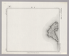
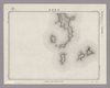
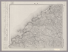
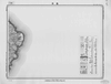
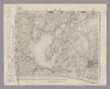
Image from the Map Collections courtesy Stanford University Libraries, licensed under a Creative Commons Attribution-Noncommercial 3.0 Unported License. © Stanford University. 【図幅名】 浦郷 【測量時期】 大正1年測図/昭和9年修正/昭和28年応急修正 【発行時期】 昭和28年8月発行 【記号】 西郷16号西部(共4面) 【測量機関】 国土地理院 【備考】 応急修正版
Links: Source / Biblio Ref
|
3 days ago | 4 control points | |
|
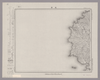
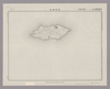
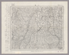
Image from the Map Collections courtesy Stanford University Libraries, licensed under a Creative Commons Attribution-Noncommercial 3.0 Unported License. © Stanford University. 【図幅名】 北方 【測量時期】 大正1年測図/昭和9年修正 【発行時期】 昭和10年8月発行 【記号】 西郷15号(共4面) 【測量機関】 大日本帝国陸地測量部 【備考】
Links: Source / Biblio Ref
|
3 days ago | 4 control points | |
|
Image from the Map Collections courtesy Stanford University Libraries, licensed under a Creative Commons Attribution-Noncommercial 3.0 Unported License. © Stanford University. 【図幅名】 美幌 【測量時期】 大正6年測図 【発行時期】 大正9年4月発行 【記号】 旭川11号(共16面) 【測量機関】 大日本帝国陸地測量部 【備考】 (In 1 layer)
Links: Source / Biblio Ref
|
3 days ago | 4 control points | |
|
Image from the Map Collections courtesy Stanford University Libraries, licensed under a Creative Commons Attribution-Noncommercial 3.0 Unported License. © Stanford University. 【図幅名】 五百石 【測量時期】 明治44年測図/昭和5年修正 【発行時期】 昭和8年3月発行 【記号】 高山9号(共16面) 【測量機関】 大日本帝国陸地測量部 【備考】
Links: Source / Biblio Ref
|
3 days ago | 4 control points | |
|
Image from the Map Collections courtesy Stanford University Libraries, licensed under a Creative Commons Attribution-Noncommercial 3.0 Unported License. © Stanford University. 【図幅名】 【測量時期】 【発行時期】 【記号】 【測量機関】 【備考】
Links: Source / Biblio Ref
|
3 days ago | 4 control points | |
|
Image from the Map Collections courtesy Stanford University Libraries, licensed under a Creative Commons Attribution-Noncommercial 3.0 Unported License. © Stanford University. 【図幅名】 【測量時期】 【発行時期】 【記号】 【測量機関】 【備考】
Links: Source / Biblio Ref
|
3 days ago | 4 control points | |
|
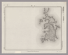
Image from the Map Collections courtesy Stanford University Libraries, licensed under a Creative Commons Attribution-Noncommercial 3.0 Unported License. © Stanford University. 【図幅名】 母島北部 【測量時期】 明治44年測圖/昭和10年修正測圖 【発行時期】 【記号】 父島十六号 【測量機関】 参謀本部 【備考】 軍事極祕(戦地ニ在りテハ軍事祕密トス)
Links: Source / Biblio Ref
|
3 days ago | 4 control points | |
|
Image from the Map Collections courtesy Stanford University Libraries, licensed under a Creative Commons Attribution-Noncommercial 3.0 Unported License. © Stanford University. 【図幅名】 【測量時期】 【発行時期】 【記号】 【測量機関】 【備考】
Links: Source / Biblio Ref
|
3 days ago | 4 control points | |
|
Image from the Map Collections courtesy Stanford University Libraries, licensed under a Creative Commons Attribution-Noncommercial 3.0 Unported License. © Stanford University. 【図幅名】 【測量時期】 【発行時期】 【記号】 【測量機関】 【備考】
Links: Source / Biblio Ref
|
3 days ago | 4 control points | |
|
Image from the Map Collections courtesy Stanford University Libraries, licensed under a Creative Commons Attribution-Noncommercial 3.0 Unported License. © Stanford University. 【図幅名】 【測量時期】 【発行時期】 【記号】 【測量機関】 【備考】
Links: Source / Biblio Ref
|
3 days ago | 4 control points | |
|
Image from the Map Collections courtesy Stanford University Libraries, licensed under a Creative Commons Attribution-Noncommercial 3.0 Unported License. © Stanford University. 【図幅名】 【測量時期】 【発行時期】 【記号】 【測量機関】 【備考】
Links: Source / Biblio Ref
|
3 days ago | 4 control points | |
|
Image from the Map Collections courtesy Stanford University Libraries, licensed under a Creative Commons Attribution-Noncommercial 3.0 Unported License. © Stanford University. 【図幅名】 【測量時期】 【発行時期】 【記号】 【測量機関】 【備考】
Links: Source / Biblio Ref
|
3 days ago | 4 control points | |
|
この地図の作成に当たっては、国土地理院長の承認を得て、同院発行の20万分の1地勢図及び5万分の1地形図を使用した。(承認番号 平30情使、 第1148号)
Links: Source / Biblio Ref
|
1946 | 3 days ago | 4 control points |
|
この地図の作成に当たっては、国土地理院長の承認を得て、同院発行の20万分の1地勢図及び5万分の1地形図を使用した。(承認番号 平30情使、 第1148号)
Links: Source / Biblio Ref
|
1946 | 3 days ago | 4 control points |
|
Image from the Map Collections courtesy Stanford University Libraries, licensed under a Creative Commons Attribution-Noncommercial 3.0 Unported License. © Stanford University. 【図幅名】 【測量時期】 【発行時期】 【記号】 【測量機関】 【備考】
Links: Source / Biblio Ref
|
3 days ago | 4 control points | |
|
この地図の作成に当たっては、国土地理院長の承認を得て、同院発行の20万分の1地勢図及び5万分の1地形図を使用した。(承認番号 平30情使、 第1148号)
Links: Source / Biblio Ref
|
1946 | 3 days ago | 3 control points |
|
Image from the Map Collections courtesy Stanford University Libraries, licensed under a Creative Commons Attribution-Noncommercial 3.0 Unported License. © Stanford University. 【図幅名】 【測量時期】 【発行時期】 【記号】 【測量機関】 【備考】
Links: Source / Biblio Ref
|
3 days ago | 4 control points | |
|
Image from the Map Collections courtesy Stanford University Libraries, licensed under a Creative Commons Attribution-Noncommercial 3.0 Unported License. © Stanford University. 【図幅名】 【測量時期】 【発行時期】 【記号】 【測量機関】 【備考】
Links: Source / Biblio Ref
|
3 days ago | 4 control points | |
|
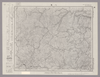
Image from the Map Collections courtesy Stanford University Libraries, licensed under a Creative Commons Attribution-Noncommercial 3.0 Unported License. © Stanford University. 【図幅名】 城端 【測量時期】 明治42年測図/昭和5年修正 【発行時期】 昭和8年12月発行 【記号】 金沢1号(共13面) 【測量機関】 大日本帝国陸地測量部 【備考】 (In 1 layer)
Links: Source / Biblio Ref
|
4 days ago | 4 control points | |
|
Image from the Map Collections courtesy Stanford University Libraries, licensed under a Creative Commons Attribution-Noncommercial 3.0 Unported License. © Stanford University. 【図幅名】 金沢 【測量時期】 明治42年測図/昭和6年修正 【発行時期】 【記号】 金沢5号 【測量機関】 参謀本部 【備考】 秘 (In 2 layers)
Links: Source / Biblio Ref
|
4 days ago | 4 control points | |
|
Image from the Map Collections courtesy Stanford University Libraries, licensed under a Creative Commons Attribution-Noncommercial 3.0 Unported License. © Stanford University. 【図幅名】 魚釣島 【測量時期】 昭和5年測圖(海上寫眞測量) 【発行時期】 昭和11年発行 【記号】 先島群島三号 【測量機関】 陸地測量部・参謀本部 【備考】 軍事極祕(戦地ニ在りテハ軍事祕密トス) 假製版
Links: Source / Biblio Ref
|
4 days ago | 4 control points | |
|
Image from the Map Collections courtesy Stanford University Libraries, licensed under a Creative Commons Attribution-Noncommercial 3.0 Unported License. © Stanford University. 【図幅名】 浜田 【測量時期】 明治32年測圖之縮圖/昭和7年修正測圖及修正測圖之縮圖 【発行時期】 【記号】 浜田十五号 【測量機関】 参謀本部 【備考】 祕
Links: Source / Biblio Ref
|
4 days ago | 4 control points | |
|
Image from the Map Collections courtesy Stanford University Libraries, licensed under a Creative Commons Attribution-Noncommercial 3.0 Unported License. © Stanford University. 【図幅名】 赤尾嶼 【測量時期】 昭和5年測圖(海上寫眞測量) 【発行時期】 昭和11年発行 【記号】 先島群島一号 【測量機関】 陸地測量部・参謀本部 【備考】 軍事極祕(戦地ニ在りテハ軍事祕密トス) 假製版
Links: Source / Biblio Ref
|
4 days ago | 4 control points | |
|
Image from the Map Collections courtesy Stanford University Libraries, licensed under a Creative Commons Attribution-Noncommercial 3.0 Unported License. © Stanford University. 【図幅名】 黄尾嶼 【測量時期】 昭和5年測圖(海上寫眞測量) 【発行時期】 昭和11年発行 【記号】 先島群島二号 【測量機関】 陸地測量部・参謀本部 【備考】 軍事極祕(戦地ニ在りテハ軍事祕密トス) 假製版
Links: Source / Biblio Ref
|
4 days ago | 4 control points | |
|
Image from the Map Collections courtesy Stanford University Libraries, licensed under a Creative Commons Attribution-Noncommercial 3.0 Unported License. © Stanford University. 【図幅名】 赤名 【測量時期】 明治32年測圖/昭和7年修正測圖 【発行時期】 【記号】 浜田七号 【測量機関】 参謀本部 【備考】 祕
Links: Source / Biblio Ref
|
4 days ago | 4 control points | |
|
Image from the Map Collections courtesy Stanford University Libraries, licensed under a Creative Commons Attribution-Noncommercial 3.0 Unported License. © Stanford University. 【図幅名】 小木 【測量時期】 大正2年測図/昭和9年修正 【発行時期】 【記号】 長岡10号(共11面) 【測量機関】 参謀本部 【備考】 秘
Links: Source / Biblio Ref
|
9 days ago | 4 control points | |
|
Image from the Map Collections courtesy Stanford University Libraries, licensed under a Creative Commons Attribution-Noncommercial 3.0 Unported License. © Stanford University. 【図幅名】 河原田 【測量時期】 大正2年測図/昭和9年修正 【発行時期】 【記号】 長岡9号 【測量機関】 参謀本部 【備考】 秘
Links: Source / Biblio Ref
|
9 days ago | 4 control points | |
|
Image from the Map Collections courtesy Stanford University Libraries, licensed under a Creative Commons Attribution-Noncommercial 3.0 Unported License. © Stanford University. 【図幅名】 岩首 【測量時期】 大正2年測図/昭和9年修正 【発行時期】 昭和10年10月発行 【記号】 長岡5号(共11面) 【測量機関】 大日本帝国陸地測量部 【備考】
Links: Source / Biblio Ref
|
9 days ago | 4 control points | |
|
Image from the Map Collections courtesy Stanford University Libraries, licensed under a Creative Commons Attribution-Noncommercial 3.0 Unported License. © Stanford University. 【図幅名】 相川 【測量時期】 大正2年測図/昭和9年修正 【発行時期】 【記号】 相川12号(共3面) 【測量機関】 参謀本部 【備考】 秘
Links: Source / Biblio Ref
|
9 days ago | 4 control points | |
|
この地図の作成に当たっては、国土地理院長の承認を得て、同院発行の20万分の1地勢図及び5万分の1地形図を使用した。(承認番号 平30情使、 第1148号)
Links: Source / Biblio Ref
|
1947 | 9 days ago | 4 control points |
|
課題のため、許諾を得てアップロード。
Links: Source / Biblio Ref
|
2024 | 9 days ago | 5 control points |
|
講義の課題で作成したものです。
Links: Source / Biblio Ref
|
2024 | 9 days ago | 3 control points |
|
Image from the Map Collections courtesy Stanford University Libraries, licensed under a Creative Commons Attribution-Noncommercial 3.0 Unported License. © Stanford University. 【図幅名】 【測量時期】 【発行時期】 【記号】 【測量機関】 【備考】
Links: Source / Biblio Ref
|
9 days ago | 4 control points | |
|
Image from the Map Collections courtesy Stanford University Libraries, licensed under a Creative Commons Attribution-Noncommercial 3.0 Unported License. © Stanford University. 【図幅名】 喜界島 【測量時期】 大正9年測圖 【発行時期】 昭和11年発行 【記号】 奄美大島要塞近傍六号 【測量機関】 陸地測量部・参謀本部 【備考】 軍事極祕(戦地ニ在りテハ軍事祕密トス)
Links: Source / Biblio Ref
|
10 days ago | 4 control points | |
|
この地図の作成に当たっては、国土地理院長の承認を得て、同院発行の20万分の1地勢図及び5万分の1地形図を使用した。(承認番号 平30情使、 第1148号)
Links: Source / Biblio Ref
|
1953 | 10 days ago | 4 control points |
|
Image from the Map Collections courtesy Stanford University Libraries, licensed under a Creative Commons Attribution-Noncommercial 3.0 Unported License. © Stanford University. 【図幅名】 平土野 【測量時期】 大正9年測圖 【発行時期】 昭和11年発行 【記号】 奄美大島要塞近傍十七号 【測量機関】 陸地測量部・参謀本部 【備考】 軍事極祕(戦地ニ在りテハ軍事祕密トス)
Links: Source / Biblio Ref
|
10 days ago | 4 control points | |
|
この地図の作成に当たっては、国土地理院長の承認を得て、同院発行の20万分の1地勢図及び5万分の1地形図を使用した。(承認番号 平30情使、 第1148号)
Links: Source / Biblio Ref
|
1953 | 10 days ago | 4 control points |
|
Image from the Map Collections courtesy Stanford University Libraries, licensed under a Creative Commons Attribution-Noncommercial 3.0 Unported License. © Stanford University. 【図幅名】 与那国島 【測量時期】 大正10年測圖 【発行時期】 昭和11年発行 【記号】 先島群島十九号 【測量機関】 陸地測量部・参謀本部 【備考】 軍事極祕(戦地ニ在りテハ軍事祕密トス)
Links: Source / Biblio Ref
|
10 days ago | 4 control points | |
|
Image from the Map Collections courtesy Stanford University Libraries, licensed under a Creative Commons Attribution-Noncommercial 3.0 Unported License. © Stanford University. 【図幅名】 霧多布 【測量時期】 大正11年測図 【発行時期】 昭和11年11月発行 【記号】 根室近傍7号(共11面) 【測量機関】 参謀本部・陸地測量部 【備考】 根室14号(共5面) 仮製版 軍事極秘 (In 1 layer)
Links: Source / Biblio Ref
|
10 days ago | 4 control points | |
|
Image from the Map Collections courtesy Stanford University Libraries, licensed under a Creative Commons Attribution-Noncommercial 3.0 Unported License. © Stanford University. 【図幅名】 利尻島東南部 【測量時期】 大正12年測圖 【発行時期】 【記号】 天塩十号 【測量機関】 参謀本部 【備考】 祕 假製版 (In 2 layers)
Links: Source / Biblio Ref
|
10 days ago | 4 control points | |
|
Image from the Map Collections courtesy Stanford University Libraries, licensed under a Creative Commons Attribution-Noncommercial 3.0 Unported License. © Stanford University. 【図幅名】 利尻島西南部 【測量時期】 大正12年測圖 【発行時期】 【記号】 天塩十四号 【測量機関】 参謀本部 【備考】 祕 假製版 (In 1 layer)
Links: Source / Biblio Ref
|
10 days ago | 4 control points | |
|
Image from the Map Collections courtesy Stanford University Libraries, licensed under a Creative Commons Attribution-Noncommercial 3.0 Unported License. © Stanford University. 【図幅名】 利尻島東北部 【測量時期】 大正12年測図 【発行時期】 昭和22年2月発行 【記号】 天塩9号(共11面) 【測量機関】 内務省地理調査所 【備考】 仮製版 (In 1 layer)
Links: Source / Biblio Ref
|
10 days ago | 4 control points | |
|
Image from the Map Collections courtesy Stanford University Libraries, licensed under a Creative Commons Attribution-Noncommercial 3.0 Unported License. © Stanford University. 【図幅名】 【測量時期】 【発行時期】 【記号】 【測量機関】 【備考】 (In 1 layer)
Links: Source / Biblio Ref
|
10 days ago | 4 control points | |
|
Image from the Map Collections courtesy Stanford University Libraries, licensed under a Creative Commons Attribution-Noncommercial 3.0 Unported License. © Stanford University. 【図幅名】 礼文島 【測量時期】 大正12年測図 【発行時期】 昭和21年10月発行 【記号】 宗谷16号(共1面) 【測量機関】 内務省地理調査所 【備考】 (In 1 layer)
Links: Source / Biblio Ref
|
10 days ago | 4 control points | |
|
Image from the Map Collections courtesy Stanford University Libraries, licensed under a Creative Commons Attribution-Noncommercial 3.0 Unported License. © Stanford University. 【図幅名】 浜松 【測量時期】 明治23年測図/大正6年修正/昭和2年部分修正/昭和22年資料修正 【発行時期】 昭和22年2月発行 【記号】 豊橋8号(共16面) 【測量機関】 地理調査所 【備考】
Links: Source / Biblio Ref
|
10 days ago | 4 control points | |
|
Image from the Map Collections courtesy Stanford University Libraries, licensed under a Creative Commons Attribution-Noncommercial 3.0 Unported License. © Stanford University. 【図幅名】 八尾 【測量時期】 明治44年測図/昭和5年修正/昭和28年応急修正 【発行時期】 昭和32年10月発行 【記号】 高山13号(共16面) 【測量機関】 国土地理院 【備考】 (In 1 layer)
Links: Source / Biblio Ref
|
15 days ago | 4 control points | |
|
Image from the Map Collections courtesy Stanford University Libraries, licensed under a Creative Commons Attribution-Noncommercial 3.0 Unported License. © Stanford University. 【図幅名】 塩野町 【測量時期】 大正2年測図/昭和6年要部修正 【発行時期】 昭和8年3月発行 【記号】 村上7号(共12面) 【測量機関】 大日本帝国陸地測量部 【備考】
Links: Source / Biblio Ref
|
15 days ago | 4 control points | |
|
この地図の作成に当たっては、国土地理院長の承認を得て、同院発行の20万分の1地勢図及び5万分の1地形図を使用した。(承認番号 平30情使、 第1148号)
Links: Source / Biblio Ref
|
1947 | 15 days ago | 4 control points |