地図を見る
| 地図 | タイトル | 年 | 前回の更新  |
ステータス |
|---|---|---|---|---|
|
リンク: 出所・参照情報
|
2020 | 約5年 前 | 6個の基準点 |
|
リンク: 出所・参照情報
|
2020 | 約5年 前 | 11個の基準点 |
|
リンク: 出所・参照情報
|
2021 | 約5年 前 | 5個の基準点 |
|
リンク: 出所・参照情報
|
2021 | 約5年 前 | 3個の基準点 |
|
リンク: 出所・参照情報
|
2020 | 約5年 前 | 5個の基準点 |
|
( 1枚のレイヤー)
リンク: 出所・参照情報
|
2020 | 約5年 前 | 13個の基準点 |
|
( 1枚のレイヤー)
リンク: 出所・参照情報
|
2020 | 約5年 前 | 17個の基準点 |
|
( 1枚のレイヤー)
リンク: 出所・参照情報
|
2020 | 約5年 前 | 11個の基準点 |
|
リンク: 出所・参照情報
|
2021 | 約5年 前 | 4個の基準点 |
|
リンク: 出所・参照情報
|
2021 | 約5年 前 | 6個の基準点 |
|
リンク: 出所・参照情報
|
2021 | 約5年 前 | 8個の基準点 |
|
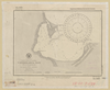
shelfmark: Maps 38.b.174
License: Public Domain
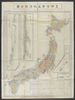
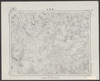
明治初期刊 *銅板。多色刷り。無刊記。北海道・樺太・千島列島・琉球諸島等を含む。英字書き入れ。赤色の線で本州・九州の旅のルートを示す。 Copperplate.
リンク: 出所・参照情報
|
約5年 前 | 27個の基準点 | |
|
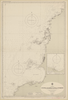
shelfmark: Maps 38.b.171
License: Public Domain
明治8 *銅板。多色刷り。外題「(蒔田愛敬編輯)皇国新図(附府県官弊国弊社)」。北海道・樺太・千島列島・琉球諸島等を含む。 Copperplate. Includes Hokkaido, Karafuto i.e., Sakhalin, the Chishima archipelago i.e., Kurile Islands and the Ryukyu islands i.e., Okinawa Prefecture.
リンク: 出所・参照情報
|
1875 | 約5年 前 | 25個の基準点 |
|
リンク: 出所・参照情報
|
2021 | 5年以上 前 | 整形を解除する |

|
リンク: 出所・参照情報
|
2021 | 5年以上 前 | 整形を解除する |
|
リンク: 出所・参照情報
|
2021 | 5年以上 前 | 整形を解除する |
|
リンク: 出所・参照情報
|
2021 | 5年以上 前 | 整形を解除する |
|
|
2021 | 5年以上 前 | 整形を解除する |
|
リンク: 出所・参照情報
|
2021 | 5年以上 前 | 整形を解除する |
|
shelfmark: Or.75.f.132
License: Public Domain
貞享年間刊 *ケンペル旧蔵。無刊記。上記のOr.75.f.131と相違あり。 Xylograph; not identical to previous entry. Ex-Kaemprer. Gardner #567.
リンク: 出所・参照情報
|
5年以上 前 | 23個の基準点 | |
|
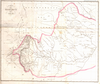
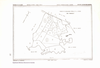
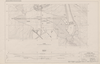
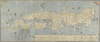
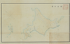
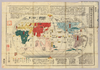
則武耕地整理組合における整理実施後の土地指定図を元に、組合から市へ移管する道路の位置を指し示したもの。数多くの水路が描かれているが、これら全てが実現したものかどうかは不明である。
|
5年以上 前 | 12個の基準点 | |
|
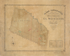
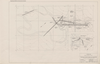
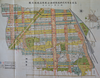
名古屋市則武耕地整理組合地区第1工区における整理前の道路、水路の状況及び地名を知ることが出来る。
|
5年以上 前 | 12個の基準点 | |
|
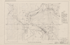
名古屋市千種耕地整理組合事業地においての地名変更の際の図面であるが、整理前の地割、道路、水路などについて非常に正確である。
|
5年以上 前 | 13個の基準点 | |

|
|
2021 | 5年以上 前 | 整形を解除する |
|
大正6年千葉県告示第四十二号
|
1917 | 5年以上 前 | 3個の基準点 |
|
リンク: 出所・参照情報
|
1936 | 5年以上 前 | 5個の基準点 |

|
|
1918 | 5年以上 前 | 3個の基準点 |
|
参謀本部陸地測量部1/50000地形図
|
1918 | 5年以上 前 | 2個の基準点 |
|
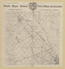
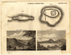
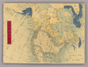
【Courtesy of the C. V. Starr East Asian Library University of California, Berkeley】 First of 4 scanned sections. Title from MS. label mounted on scroll. Hand scroll. Hand drawn col. panoramic map. In Japanese. Orientation varies. East Asian Library call number: MJ02.
リンク: 出所・参照情報
|
1687 | 5年以上 前 | 3個の基準点 |
|
|
1945 | 5年以上 前 | 整形を解除する |
|
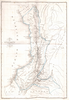
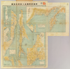
明治16(1883)年11月、京都府から琵琶湖疏水事業の起工伺書が提出されます。内務省はお雇い外国人デ・レーケの実地調査などから、脆弱な工法を補強し、京都府案の倍余の工事費となる内務省土木局設計書を示します。そして、京都府上下京連合区会において、土木局案での議決をとり、さらに伺い出るよう指令します。また、隣接する大阪府・滋賀県に発生する水干害予防の工事費負担も問題となります。連合区会で工事費増額が認められ、明治18(1885)年1月、起工が許可されます。本図の含まれる「公文附属の図」は、平成10年「公文録」とともに、国の重要文化財に指定されました。
明治18(1885)年1月に起工が許可されたときの、起工許可関係文書に附属する疏水路図です。原図サイズ:119cm×187cm
リンク: 出所・参照情報
|
1885 | 5年以上 前 | 7個の基準点 |
|
明治18年国道図.第二回目
|
1885 | 5年以上 前 | 3個の基準点 |

|
明治18年国道図
リンク: 出所・参照情報
|
1885 | 5年以上 前 | 5個の基準点 |
|
Map from Suikeichuzu
|
5年以上 前 | 5個の基準点 | |
|
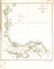
【Courtesy of the C. V. Starr East Asian Library University of California, Berkeley】 Wood block print. In Japanese. Oriented with north toward upper right. Includes an oversize Puget Sound and shows 3 of the Great Lakes as one large body. East Asian Library call number: A15.
リンク: 出所・参照情報
|
1856 | 5年以上 前 | 4個の基準点 |
|
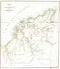
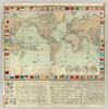
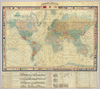
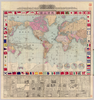
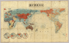
【Courtesy of the C. V. Starr East Asian Library University of California, Berkeley】 Mounted cover title. Copperplate print. In Japanese. Relief shown by hachures. Shows sea routes. Includes 4 insets, text on history, national flags, and legend. Prime meridian: Tokyo. Col., folded in cover 19 x 12 cm. East Asian Library call number: A20.
リンク: 出所・参照情報
|
1874 | 5年以上 前 | 4個の基準点 |
|
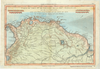
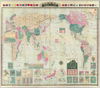
【Courtesy of the C. V. Starr East Asian Library University of California, Berkeley】 Title added by hand. Title in Kobe Shiritsu Hakubutsukan kanzobin mokuroku p.11 : Zotei yochi kokai zenzu. Wood block print. In Japanese. Relief shown by hachures. Shows sea routes and views of capital cities. Includes distance chart of sea routes, charts of mountains, and rivers, and national flags. Includes preface and legend. Col., folded in cover 32 x 20 cm. East Asian Library call number: A27.
リンク: 出所・参照情報
|
1875 | 5年以上 前 | 4個の基準点 |
|
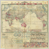
【Courtesy of the C. V. Starr East Asian Library University of California, Berkeley】 Mounted cover title. Wood block print. In Japanese. Title on map: Chikyu Bankoku sankai yochi zen zusetsu. Includes texts on the earth and climate zones, etc. Col., folded to 19 x 12 cm. East Asian Library call number: A3.
リンク: 出所・参照情報
|
1850 | 5年以上 前 | 4個の基準点 |
|
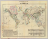
【Courtesy of the C. V. Starr East Asian Library University of California, Berkeley】 Mounted cover title. Copperplate print. In Japanese. Includes 18 insets, national flags, and charts of mountains and rivers. Shows sea routes and views of capital cities. Includes preface and legend. Col., folded in cover 19 x 13 cm. East Asian Library call number: A31.
リンク: 出所・参照情報
|
1876 | 5年以上 前 | 4個の基準点 |
|
【Courtesy of the C. V. Starr East Asian Library University of California, Berkeley】 Mounted cover title. Title on map: Bankoku seizu. Copperplate print. In Japanese. Shows views of capital cities. Includes 3 insets, charts of rivers, and mountains, and national flags. Prime meridian: Tokyo. Col., folded in cover 21 x 15 cm. East Asian Library call number: A32.
リンク: 出所・参照情報
|
1886 | 5年以上 前 | 4個の基準点 |
|
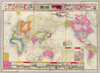
【Courtesy of the C. V. Starr East Asian Library University of California, Berkeley】 Cover title. Title on map: Bankoku zenzu. Copperplate print. In Japanese. Relief shown by hachures. Includes 4 insets, national flags and legend. Shows distance of sea routes. Col., folded in cover 19 x 13 cm. East Asian Library call number: A43.
リンク: 出所・参照情報
|
1887 | 5年以上 前 | 4個の基準点 |
|
【Courtesy of the C. V. Starr East Asian Library University of California, Berkeley】 Cover title. Title on map: Yogo sonyu shintei bankoku yochi zenzu. Copperplate print. In Japanese and English. Relief shown by hachures. Shows distance of sea routes. Includes 21 insets, charts of mountains and rivers, and national flags. Includes distance chart of sea routes and legend. Col., folded in cover 22 x 15 cm. East Asian Library call number: A45.
リンク: 出所・参照情報
|
1887 | 5年以上 前 | 4個の基準点 |
|
【Courtesy of the C. V. Starr East Asian Library University of California, Berkeley】 Cover title. In Japanese. Relief shown by hachures. Shows distance of sea routes. Includes lists of country names and time differentials and legend. Col., folded in cover 25 x 16 cm. East Asian Library call number: A48.
リンク: 出所・参照情報
|
1889 | 5年以上 前 | 4個の基準点 |
|
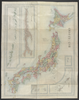
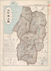
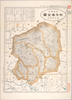
【Courtesy of the C. V. Starr East Asian Library University of California, Berkeley】 Title on map: Saishin Yamagata-ken zenzu. In Japanese. Relief shown by hachures. Includes list of addresses and legend.
リンク: 出所・参照情報
|
1908 | 5年以上 前 | 4個の基準点 |
|
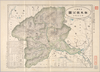
【Courtesy of the C. V. Starr East Asian Library University of California, Berkeley】 Title on envelope : Saishin Tochigi-ken zenzu. In Japanese. Relief shown by hachures. Include address chart and legend.
リンク: 出所・参照情報
|
1907 | 5年以上 前 | 4個の基準点 |
|
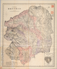
【Courtesy of the C. V. Starr East Asian Library University of California, Berkeley】 Title on envelope : Saishin Gunma-ken zenzu. In Japanese. Relief shown by hachures. Includes address chart and legend.
リンク: 出所・参照情報
|
1907 | 5年以上 前 | 4個の基準点 |
|
【Courtesy of the C. V. Starr East Asian Library University of California, Berkeley】 Cover title. In Japanese. Includes 1 inset : Utsunomiya shigai no zu. Includes legend.
リンク: 出所・参照情報
|
1893 | 5年以上 前 | 4個の基準点 |
|
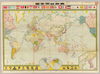
【Courtesy of the C. V. Starr East Asian Library University of California, Berkeley】 In Japanese. Relief shown by hachures. Shows distance of sea routes. Includes 2 insets, national flags, drawings of races, and legend. Col., folded to 27 x 19 cm. + 1 booklet not scanned. East Asian Library call number: A58.1.
リンク: 出所・参照情報
|
1905 | 5年以上 前 | 4個の基準点 |
|
【Courtesy of the C. V. Starr East Asian Library University of California, Berkeley】 Mounted cover title. Wood block print. In Japanese. Includes legend. Col., folded in cover. East Asian Library call number: A7.
リンク: 出所・参照情報
|
1853 | 5年以上 前 | 4個の基準点 |
|
【Courtesy of the C. V. Starr East Asian Library University of California, Berkeley】 Cover title. Title on map: Jiji Shinpo Karafuto oyobi Kamuchakka zenzu. In Japanese. Relief shown by hachures and spot heights. Includes 6 insets and legend. Col., folded in cover 20 x 14 cm. East Asian Library call number: Be2.
リンク: 出所・参照情報
|
1905 | 5年以上 前 | 4個の基準点 |