地図を見る
| 地図 | タイトル | 年 | 前回の更新 | ステータス  |
|---|---|---|---|---|
|
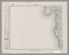
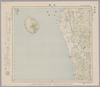
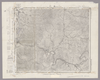
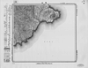
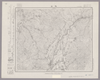
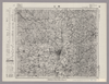
Image from the Map Collections courtesy Stanford University Libraries, licensed under a Creative Commons Attribution-Noncommercial 3.0 Unported License. © Stanford University. 【図幅名】 富来 【測量時期】 明治43年測図/昭和9年修正 【発行時期】 昭和11年8月発行 【記号】 七尾6号(共7面) 【測量機関】 大日本帝国陸地測量部 【備考】
リンク: 出所・参照情報
|
3ヶ月 前 | 4個の基準点 | |
|
|
2019 | 5年以上 前 | 4個の基準点 |
|
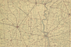
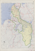
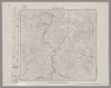
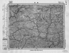
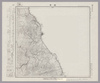
Image from the Map Collections courtesy Stanford University Libraries, licensed under a Creative Commons Attribution-Noncommercial 3.0 Unported License. © Stanford University. 【図幅名】 苗場山 【測量時期】 大正1年測図/昭和6年要部修正 【発行時期】 【記号】 高田7号 【測量機関】 参謀本部 【備考】 秘
リンク: 出所・参照情報
|
2ヶ月 前 | 4個の基準点 | |
|
|
2019 | 5年以上 前 | 4個の基準点 |
|
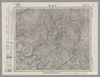
Image from the Map Collections courtesy Stanford University Libraries, licensed under a Creative Commons Attribution-Noncommercial 3.0 Unported License. © Stanford University.
リンク: 出所・参照情報
|
6年以上 前 | 4個の基準点 | |
|
|
2019 | 5年以上 前 | 6個の基準点 |
|
Image from the Map Collections courtesy Stanford University Libraries, licensed under a Creative Commons Attribution-Noncommercial 3.0 Unported License. © Stanford University.
リンク: 出所・参照情報
|
6年以上 前 | 4個の基準点 | |
|
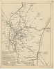
Image from the Map Collections courtesy Stanford University Libraries, licensed under a Creative Commons Attribution-Noncommercial 3.0 Unported License. © Stanford University. 【図幅名】 柏崎 【測量時期】 明治44年測図/昭和6年修正 【発行時期】 昭和9年4月発行 【記号】 長岡8号(共11面) 【測量機関】 大日本帝国陸地測量部 【備考】
リンク: 出所・参照情報
|
2ヶ月 前 | 4個の基準点 | |
|
リンク: 出所・参照情報
|
2020 | 約2年 前 | 4個の基準点 |
|
|
2022 | 約2年 前 | 5個の基準点 |
|
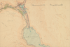
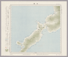
Image from the Map Collections courtesy Stanford University Libraries, licensed under a Creative Commons Attribution-Noncommercial 3.0 Unported License. © Stanford University. 【図幅名】 七尾 【測量時期】 明治43年測図/昭和4年修正 【発行時期】 【記号】 七尾2号(共7面) 【測量機関】 参謀本部 【備考】 秘
リンク: 出所・参照情報
|
3ヶ月 前 | 4個の基準点 | |
|
|
2022 | 約2年 前 | 4個の基準点 |
|
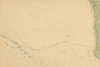
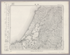
Image from the Map Collections courtesy Stanford University Libraries, licensed under a Creative Commons Attribution-Noncommercial 3.0 Unported License. © Stanford University. 【図幅名】 津川 【測量時期】 明治44年測図/昭和6年修正、測図の縮図 【発行時期】 昭和9年7月発行 【記号】 新潟10号(共16面) 【測量機関】 大日本帝国陸地測量部 【備考】
リンク: 出所・参照情報
|
2年以上 前 | 4個の基準点 | |
|
|
2022 | 約2年 前 | 7個の基準点 |
|
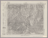
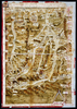
Image from the Map Collections courtesy Stanford University Libraries, licensed under a Creative Commons Attribution-Noncommercial 3.0 Unported License. © Stanford University. 【図幅名】 大日岳 【測量時期】 大正2年測図/昭和6年要部修正 【発行時期】 【記号】 新潟6号 【測量機関】 参謀本部 【備考】 秘
リンク: 出所・参照情報
|
2年以上 前 | 4個の基準点 | |
|
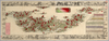
【Courtesy of the C. V. Starr East Asian Library University of California, Berkeley】 Japanese date Meiji 17 1884. In color. Folded. Mounted cover title. Title on map: Dai Nihon fuken meisho hitori annai : fu tokai benran meisho eiri. Copperplate print. In Japanese. Orientation varies. Bird's-eye view. Shows views of tourist attractions. Includes list of city names and distance chart.
リンク: 出所・参照情報
|
1884 | 4年弱 前 | 5個の基準点 |
|
この地図の作成に当たっては、国土地理院長の承認を得て、同院発行の20万分の1地勢図及び5万分の1地形図を使用した。(承認番号 平30情使、 第1148号)
リンク: 出所・参照情報
|
1946 | 2ヶ月 前 | 4個の基準点 |
|
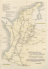
【Courtesy of the C. V. Starr East Asian Library University of California, Berkeley】 Japanese date Bunsei 5 1822. In color. Folded. Printed 2 sides. Cover title. Wood block print. In Japanese. Orientation varies. Covers Nagasaki to Morioka. Includes lists of messenger fees on verso. Includes legend.
リンク: 出所・参照情報
|
1822 | 4年弱 前 | 4個の基準点 |
|
この地図の作成に当たっては、国土地理院長の承認を得て、同院発行の20万分の1地勢図及び5万分の1地形図を使用した。(承認番号 平30情使、 第1148号)
リンク: 出所・参照情報
|
1947 | 5年以上 前 | 4個の基準点 |

|
|
2023 | 1年以上 前 | 8個の基準点 |
|
Image from the Map Collections courtesy Stanford University Libraries, licensed under a Creative Commons Attribution-Noncommercial 3.0 Unported License. © Stanford University. 【図幅名】 上江丹別 【測量時期】 大正8年測図/昭和6年鉄道補入 【発行時期】 昭和8年1月発行 【記号】 旭川13号(共16面) 【測量機関】 大日本帝国陸地測量部 【備考】 ( 1枚のレイヤー)
リンク: 出所・参照情報
|
2年以上 前 | 4個の基準点 | |

|
Image from the Map Collections courtesy Stanford University Libraries, licensed under a Creative Commons Attribution-Noncommercial 3.0 Unported License. © Stanford University. 【図幅名】 大原 【測量時期】 明治36年測図/昭和6年修正 【発行時期】 【記号】 大多喜9号(共4面) 【測量機関】 参謀本部 【備考】 秘 ( 1枚のレイヤー)
リンク: 出所・参照情報
|
2ヶ月 前 | 4個の基準点 | |
|
Image from the Map Collections courtesy Stanford University Libraries, licensed under a Creative Commons Attribution-Noncommercial 3.0 Unported License. © Stanford University. 【図幅名】 飯山 【測量時期】 明治44年測図/昭和5年修正 【発行時期】 【記号】 高田11号(共15面) 【測量機関】 内務省地理調査所 【備考】
リンク: 出所・参照情報
|
2ヶ月 前 | 4個の基準点 | |
|
|
2020 | 4年弱 前 | 9個の基準点 |
|
この地図の作成に当たっては、国土地理院長の承認を得て、同院発行の20万分の1地勢図及び5万分の1地形図を使用した。(承認番号 平30情使、 第1148号)
リンク: 出所・参照情報
|
1947 | 11日 前 | 4個の基準点 |
|
Image from the Map Collections courtesy Stanford University Libraries. This item is in the public domain. There are no restrictions on use.
【図幅名】 春牟古丹島西部【測量時期】 大正5年測圖 【発行時期】昭和11年 【記号】 捨子古丹島十号 【測量機関】 参謀本部 【その他】千島列島 陸地測量部
リンク: 出所・参照情報
|
1936 | 1年以上 前 | 4個の基準点 |
|
Image from the Map Collections courtesy Stanford University Libraries, licensed under a Creative Commons Attribution-Noncommercial 3.0 Unported License. © Stanford University.
リンク: 出所・参照情報
|
6年以上 前 | 4個の基準点 | |
|
Image from the Map Collections courtesy Stanford University Libraries, licensed under a Creative Commons Attribution-Noncommercial 3.0 Unported License. © Stanford University. 【図幅名】 勝浦 【測量時期】 明治36年測図/昭和6年修正 【発行時期】 昭和8年8月発行 【記号】 大多喜10号(共4面) 【測量機関】 大日本帝国陸地測量部 【備考】 ( 1枚のレイヤー)
リンク: 出所・参照情報
|
2ヶ月 前 | 4個の基準点 | |
|
リンク: 出所・参照情報
|
2021 | 1年以上 前 | 5個の基準点 |
|
Image from the Map Collections courtesy Stanford University Libraries. This item is in the public domain. There are no restrictions on use.
【図幅名】 春牟古丹島東部【測量時期】 大正5年測圖 【発行時期】昭和11年 【記号】 捨子古丹島六号 【測量機関】 参謀本部 【その他】千島列島 陸地測量部
リンク: 出所・参照情報
|
1936 | 1年以上 前 | 4個の基準点 |
|
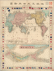
【Courtesy of the C. V. Starr East Asian Library University of California, Berkeley】 Contents: Chikyu oyobi Dai Nihon shinzu.--Dai Nihonkoku zenzu.Mounted cover title. 2 maps : col. ; 23 x 31 cm. and 15 x 31 cm., on sheet 48 x 37 cm., folded in cover 16 x 10 cm. Copperplate print. In Japanese. Orientation varies. Relief shown by hachures. Includes distance chart of sea routes, national flags, list of local products, and legend. East Asian Library call number: A26.
リンク: 出所・参照情報
|
1875 | 3年以上 前 | 4個の基準点 |
|
|
2020 | 4年弱 前 | 3個の基準点 |
|
Image from the Map Collections courtesy Stanford University Libraries, licensed under a Creative Commons Attribution-Noncommercial 3.0 Unported License. © Stanford University. 【図幅名】 盛 【測量時期】 大正2年測図/昭和8年修正 【発行時期】 昭和11年4月発行 【記号】 一関6号(共14面) 【測量機関】 大日本帝国陸地測量部 【備考】
リンク: 出所・参照情報
|
2年以上 前 | 4個の基準点 | |
|
Image from the Map Collections courtesy Stanford University Libraries, licensed under a Creative Commons Attribution-Noncommercial 3.0 Unported License. © Stanford University. 【図幅名】 築別 【測量時期】 大正11年測図 【発行時期】 大正13年5月発行 【記号】 羽幌2号(共8面) 【測量機関】 大日本帝国陸地測量部 【備考】 仮製版 ( 1枚のレイヤー)
リンク: 出所・参照情報
|
2ヶ月 前 | 4個の基準点 | |
|
リンク: 出所・参照情報
|
2020 | 2年弱 前 | 9個の基準点 |
|
|
2022 | 約2年 前 | 5個の基準点 |
|
Image from the Map Collections courtesy Stanford University Libraries, licensed under a Creative Commons Attribution-Noncommercial 3.0 Unported License. © Stanford University. 【図幅名】 甲浦 【測量時期】 明治40年測圖/昭和8年修正測圖 【発行時期】 【記号】 剣山十一号 【測量機関】 参謀本部 【備考】 祕
リンク: 出所・参照情報
|
6年弱 前 | 4個の基準点 | |
|
Image from the Map Collections courtesy Stanford University Libraries, licensed under a Creative Commons Attribution-Noncommercial 3.0 Unported License. © Stanford University. 【図幅名】 名寄 【測量時期】 大正11年測図 【発行時期】 昭和22年1月発行 【記号】 名寄10号(共16面) 【測量機関】 内務省地理調査所 【備考】 ( 1枚のレイヤー)
リンク: 出所・参照情報
|
2ヶ月 前 | 4個の基準点 | |
|
リンク: 出所・参照情報
|
2018 | 6年以上 前 | 3個の基準点 |
|
|
2022 | 約2年 前 | 5個の基準点 |
|
リンク: 出所・参照情報
|
2020 | 2年弱 前 | 3個の基準点 |
|
リンク: 出所・参照情報
|
2020 | 約3年 前 | 4個の基準点 |
|
Image from the Map Collections courtesy Stanford University Libraries, licensed under a Creative Commons Attribution-Noncommercial 3.0 Unported License. © Stanford University. 【図幅名】 郡山 【測量時期】 明治41年測図/昭和6年要部修正 【発行時期】 昭和8年9月発行 【記号】 福島12号(共18面) 【測量機関】 大日本帝国陸地測量部 【備考】
リンク: 出所・参照情報
|
2ヶ月 前 | 4個の基準点 | |
|
Image from the Map Collections courtesy Stanford University Libraries, licensed under a Creative Commons Attribution-Noncommercial 3.0 Unported License. © Stanford University. 【図幅名】 枝幸 【測量時期】 大正12年測図 【発行時期】 大正13年6月発行 【記号】 枝幸7号(共12面) 【測量機関】 大日本帝国陸地測量部 【備考】 仮製版 ( 1枚のレイヤー)
リンク: 出所・参照情報
|
2ヶ月 前 | 4個の基準点 | |
|
Image from the Map Collections courtesy Stanford University Libraries, licensed under a Creative Commons Attribution-Noncommercial 3.0 Unported License. © Stanford University. 【図幅名】 鮫 【測量時期】 大正3年測図/大正10年鉄道補入 【発行時期】 昭和2年4月発行 【記号】 八戸5号(共15面) 【測量機関】 大日本帝国陸地測量部 【備考】
リンク: 出所・参照情報
|
約1ヶ月 前 | 4個の基準点 | |
|
|
2023 | 1年以上 前 | 5個の基準点 |
|
Image from the Map Collections courtesy Stanford University Libraries, licensed under a Creative Commons Attribution-Noncommercial 3.0 Unported License. © Stanford University. 【図幅名】 平戸 【測量時期】 大正12年測図の縮図/昭和10年修正、測図の縮図 【発行時期】 昭和21年11月発行 【記号】 唐津8号(共12面) 【測量機関】 地理調査所 【備考】
リンク: 出所・参照情報
|
約1ヶ月 前 | 4個の基準点 | |
|
Image from the Map Collections courtesy Stanford University Libraries, licensed under a Creative Commons Attribution-Noncommercial 3.0 Unported License. © Stanford University. 【図幅名】 丸瀬布 【測量時期】 大正13年測図/昭和3年鉄道補入 【発行時期】 昭和21年10月発行 【記号】 淕別9号(共16面) 【測量機関】 内務省地理調査所 【備考】 ( 1枚のレイヤー)
リンク: 出所・参照情報
|
2年以上 前 | 4個の基準点 | |
|
【Courtesy of the C. V. Starr East Asian Library University of California, Berkeley】
リンク: 出所・参照情報
|
1868 | 3年以上 前 | 4個の基準点 |
|
|
2023 | 1年以上 前 | 7個の基準点 |