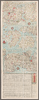
shelfmark: Maps *62980.13 License: Public Domain 江戸後期 *多色刷り。(刊記書肆)発行書坊/東都、和泉屋[破損]・山城屋佐兵衛・山城屋政七/京都、菊屋七郎兵衛・山城屋佐兵衛/尾陽、永楽屋東四郎/伏陽、亀屋半兵衛/大阪、石川屋和助・藤屋菊治郎。 Xylograph. Beans 33. A collection of historical maps of Japan covering the period 1184-1615. アップロード者: autobot. 最終更新日時 6年以上 前. 整形を解除する.
タグ
リンク: 出所・参照情報 |
 WMS CapabilitiesのURL
 タイル(Google・OSMのフォーマット)
 基準点をCSVでダウンロードする