shelfmark: Maps *62870.1 License: Public Domain 天明5 *多色刷。 Manuscript, early 19th century. Some additions made in roman script. アップロード者: autobot. 作成: 1785 最終更新日時 6年以上 前. 整形を解除する.
タグ
リンク: 出所・参照情報 |
|
|
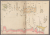
琉球三省並三十六島之図 Ryukyu sansho narabi ni sanjurokuto no zu Map of the three provinces and thrity-six islands of the Ryukyu islands
shelfmark: Maps *62870.1 License: Public Domain 天明5 *多色刷。 Manuscript, early 19th century. Some additions made in roman script. アップロード者: autobot. 作成: 1785 最終更新日時 6年以上 前. 整形を解除する. タグ リンク: 出所・参照情報 | |
タイトル
琉球三省並三十六島之図 Ryukyu sansho narabi ni sanjurokuto no zu [Map of the three provinces and thrity-six islands of the Ryukyu islands]
説明
shelfmark: Maps *62870.(1)
License: Public Domain
天明5 *多色刷。 Manuscript, early 19th century. Some additions made in roman script.
タグ:
is_map
出所・参照情報のURL
https://www.bl.uk/
出版者
須原屋市兵衛
作成者
林子平図 Hayashi Shihei (1738-1793)
縮尺
出版年月日
再版年月日
 WMS CapabilitiesのURL
 タイル(Google・OSMのフォーマット)
 基準点をCSVでダウンロードする