Tags for UCB
| Map | Title | Year | Last Updated | Status  |
|---|---|---|---|---|
|
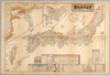
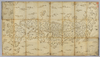
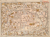
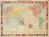
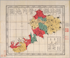
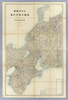
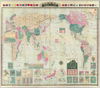
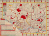
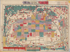
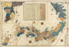
【Courtesy of the C. V. Starr East Asian Library University of California, Berkeley】 Japanese date Meiji 28 1895. In color. Folded. Title on envelope: Kaisei jissoku Dai Nihon shinchizu : fu shinryōchi Taiwan chizu. In Japanese. Oriented with north to the upper right. Relief shown by hachures. Includes 6 insets: Manshū Shinkoku.--Hokkaidō.--Shinryōchi Taiwan zenzu ... et al.. Includes list of district names, charts of mountains and rivers, and legend. Shows sea routes with distances.
Links: Source / Biblio Ref
|
1895 | over 3 years ago | 4 control points |
|
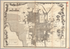
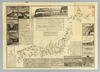
【Courtesy of the C. V. Starr East Asian Library University of California, Berkeley】 Japanese date Meiji 36 1903. Folded. Title on envelope: Eibun Kyōto jissoku shinchizu = Kyoto new atlas. In Japanese and English. Oriented with north to the upper right. Relief shown by hachures. Includes legend.
Links: Source / Biblio Ref
|
1903 | over 3 years ago | 4 control points |
|
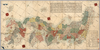
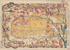
【Courtesy of the C. V. Starr East Asian Library University of California, Berkeley】 Japanese date Kaei 2 1849. In color. Folded. Wood block print. In Japanese. Oriented with north to the upper right. Covers Matsumae to Tsushima and Ryūkyū. Title from: Nihon chizushi / Akioka Takejirō. p.152. Shows longitudes and latitudes and Kuroshio. Includes distance chart and legend. Shows distances of the sea routes. Title on library's envelope.
Links: Source / Biblio Ref
|
1849 | over 3 years ago | 5 control points |
|
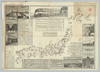
【Courtesy of the C. V. Starr East Asian Library University of California, Berkeley】 Cover title. Copperplate print. In Japanese. Oriented with north to the upper right. Relief shown pictorially. Includes views of points of interest, time table, fare table, freight table, railroad company names, and legend. Detailed views emphasize engineering accomplishments such as bridges, tunnels, power lines, buildings, and railroads. Folded in cover 14 x 20 cm.
Links: Source / Biblio Ref
|
1888 | over 3 years ago | 5 control points |
|
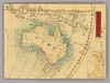
【Courtesy of the C. V. Starr East Asian Library University of California, Berkeley】 1 map : hand col. ; 60 x 107 cm., folded in cover 21 x 15 cm. Notes Mounted cover title. Wood block print. In Japanese. Covers Matsumae to Tsushima, Tojima, Ryukyu, and Hachijojima. Shows distance of sea routes. Includes legend. East Asian Library call number Ca 19.
Links: Source / Biblio Ref
|
1730 | over 3 years ago | 5 control points |
|
【Courtesy of the C. V. Starr East Asian Library University of California, Berkeley】 1 map : hand col. ; 85 x 140 cm., folded to 29 x 17 cm. Mounted cover title. Wood block print. In Japanese. Covers Matsumae to Tsushima, Yakushima, and Hachijojima. Oriented with north to the upper right. Preface by Shibano Ritsuzan. Engraved by Inoue Jihe. Shows longitude and latitude. Includes legend, distance chart of sea routes, and explanation of Kuroshio and tides. East Asian Library call number Ca 17.1.
Links: Source / Biblio Ref
|
1811 | over 3 years ago | 5 control points |
|
【Courtesy of the C. V. Starr East Asian Library University of California, Berkeley】 1 map: hand col.; on sheet 71 x 163 cm., folded in cover 24 x 14 cm. Mounted cover title. Wood block print. In Japanese. Covers Matsumae to Tsushima and Ryukyu. Includes text and legend. Shows the distance of sea routes. Alternate Title: Nihonkoku oezu. East Asian Library call number Ca 43.
Links: Source / Biblio Ref
|
1685 | over 3 years ago | 5 control points |
|
【Courtesy of the C. V. Starr East Asian Library University of California, Berkeley】 1 map : col. ; 143 x 103 cm., folded in cover 26 x 19 cm. Mounted cover title. Copperplate print. Relief shown by hachures. In Japanese. Includes distance chart and legend. Insets: Higashihankyu -- Nishihankyu -- Hokkaido tohokugu Chishima Shoto no zu -- Ryukyu Shoto no zu. East Asian Library call number: Cb35.
Links: Source / Biblio Ref
|
1876 | over 3 years ago | 4 control points |
|
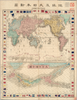
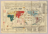
【Courtesy of the C. V. Starr East Asian Library University of California, Berkeley】 Contents: Chikyu oyobi Dai Nihon shinzu.--Dai Nihonkoku zenzu.Mounted cover title. 2 maps : col. ; 23 x 31 cm. and 15 x 31 cm., on sheet 48 x 37 cm., folded in cover 16 x 10 cm. Copperplate print. In Japanese. Orientation varies. Relief shown by hachures. Includes distance chart of sea routes, national flags, list of local products, and legend. East Asian Library call number: A26.
Links: Source / Biblio Ref
|
1875 | over 3 years ago | 4 control points |
|
【Courtesy of the C. V. Starr East Asian Library University of California, Berkeley】 Wood block print. In Japanese. Shows New Zealand in inset. East Asian Library call number: A15.
Links: Source / Biblio Ref
|
1856 | about 2 years ago | 9 control points |
|
【Courtesy of the C. V. Starr East Asian Library University of California, Berkeley】 Japanese date Genji 1 1864. Folded. Mounted cover title. Wood block print. In Japanese. Relief shown pictorially. Includes distance chart. Shows land tenures of daimyo.
Links: Source / Biblio Ref
|
1864 | over 3 years ago | 4 control points |
|
【Courtesy of the C. V. Starr East Asian Library University of California, Berkeley】 Mounted cover title. Hand col. wood block print. In Japanese. Relief shown pictorially. Includes distance chart and index. Folded in cover 23 x 16 cm. East Asian Library call number: F6.
Links: Source / Biblio Ref
|
1717 | over 3 years ago | 4 control points |
|
【Courtesy of the C. V. Starr East Asian Library University of California, Berkeley】 Mounted cover title. Wood block print. In Japanese. Oriented with north to the left. Relief shown pictorially. Includes legend.
Links: Source / Biblio Ref
|
1786 | over 3 years ago | 4 control points |
|
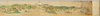
【Courtesy of the C. V. Starr East Asian Library University of California, Berkeley】 First of 4 scanned sections. Title from MS. label mounted on scroll. Hand scroll. Hand drawn col. panoramic map. In Japanese. Orientation varies. East Asian Library call number: MJ02.
Links: Source / Biblio Ref
|
1687 | about 3 years ago | 3 control points |
|
【Courtesy of the C. V. Starr East Asian Library University of California, Berkeley】 Wood block print. In Japanese. Oriented with north toward upper right. Includes an oversize Puget Sound and shows 3 of the Great Lakes as one large body. East Asian Library call number: A15.
Links: Source / Biblio Ref
|
1856 | over 3 years ago | 4 control points |
|
【Courtesy of the C. V. Starr East Asian Library University of California, Berkeley】 Lithograph. In Japanese. Relief shown by hachures. Col. map folded in cover 20 x 14 cm. East Asian Library call number Bd4.
Links: Source / Biblio Ref
|
1895 | over 3 years ago | 4 control points |
|
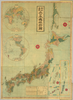
【Courtesy of the C. V. Starr East Asian Library University of California, Berkeley】 Mounted cover title. Col. copperplate print. In Japanese. Relief shown by hachures. Shows distance sea routes. Includes text on earth, list of populations, national flags, and legend. Folded in cover 13x 9 cm. East Asian Library call number: A19.
Links: Source / Biblio Ref
|
1868 | over 3 years ago | 4 control points |
|
【Courtesy of the C. V. Starr East Asian Library University of California, Berkeley】 Mounted cover title. Wood block print. In Japanese. Shows distances.
Links: Source / Biblio Ref
|
1763 | over 3 years ago | 4 control points |
|
【Courtesy of the C. V. Starr East Asian Library University of California, Berkeley】 Copperplate print. In Japanese. Oriented with north to the left. Relief shown pictorially. Includes distance chart, index, and legend.
Links: Source / Biblio Ref
|
1879 | over 3 years ago | 4 control points |
|
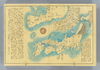
【Courtesy of the C. V. Starr East Asian Library University of California, Berkeley】 Wood block print. In Japanese. Oriented with north toward right. East Asian Library call number: A15.
Links: Source / Biblio Ref
|
1856 | about 2 years ago | 8 control points |
|
【Courtesy of the C. V. Starr East Asian Library University of California, Berkeley】 1 map : col. ; 112 x 75 cm., folded in cover 21 x 21 cm. In Japanese. Relief shown by contours and spot heights. Includes 2 insets and legend. East Asian Library call number: Cb120.1.
Links: Source / Biblio Ref
|
1894 | over 3 years ago | 4 control points |
|
【Courtesy of the C. V. Starr East Asian Library University of California, Berkeley】 Col. map.
Links: Source / Biblio Ref
|
1895 | over 3 years ago | 4 control points |
|
【Courtesy of the C. V. Starr East Asian Library University of California, Berkeley】 Copperplate print. In Japanese. Oriented with north to the right. Relief shown by hachures. Includes distance chart and legend.
Links: Source / Biblio Ref
|
1868 | over 3 years ago | 4 control points |
|
【Courtesy of the C. V. Starr East Asian Library University of California, Berkeley】 Mounted cover title. Copperplate print. In Japanese. Includes 18 insets, national flags, and charts of mountains and rivers. Shows sea routes and views of capital cities. Includes preface and legend. Col., folded in cover 19 x 13 cm. East Asian Library call number: A31.
Links: Source / Biblio Ref
|
1876 | over 3 years ago | 4 control points |
|
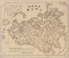
【Courtesy of the C. V. Starr East Asian Library University of California, Berkeley】 Mounted cover title. Title on map: Fukui-ken kannai chizu. Wood block print. In Japanese. Relief shown by hachures.
Links: Source / Biblio Ref
|
1883 | over 3 years ago | 4 control points |
|
【Courtesy of the C. V. Starr East Asian Library University of California, Berkeley】 Mounted cover title. Wood block print. Oriented with north to the left. In Japanese. Relief shown pictorially. Includes legend. Engraved by Okada Mohe.
Links: Source / Biblio Ref
|
1843 | over 3 years ago | 4 control points |
|
【Courtesy of the C. V. Starr East Asian Library University of California, Berkeley】 1 map : col. ; 77 x 75 cm., folded in cover 23 x 16 cm. Mounted cover title. Copperplate print. In Japanese, English and romanized Japanese. Relief shown by hachures. Includes 1 inset and legend. East Asian Library call number: D8.
Links: Source / Biblio Ref
|
1883 | over 3 years ago | 4 control points |
|
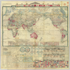
【Courtesy of the C. V. Starr East Asian Library University of California, Berkeley】 Mounted cover title. Wood block print. In Japanese. Title on map: Chikyu Bankoku sankai yochi zen zusetsu. Includes texts on the earth and climate zones, etc. Col., folded to 19 x 12 cm. East Asian Library call number: A3.
Links: Source / Biblio Ref
|
1850 | over 3 years ago | 4 control points |
|
【Courtesy of the C. V. Starr East Asian Library University of California, Berkeley】 1 map : col. ; 116 x 73 cm., folded in cover 21 x 21 cm. In Japanese. Relief shown by contours and spot heights. Includes 1 inset and legend. East Asian Library call number: Cb132.2.
Links: Source / Biblio Ref
|
1890 | over 3 years ago | 4 control points |
|
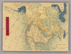
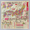
【Courtesy of the C. V. Starr East Asian Library University of California, Berkeley】 1 map : col. ; 46 x 65 cm., folded in cover 22 x 15 cm. Mounted cover title. Copperplate print. In Japanese and English. Oriented with north to the upper right. Relief shown by hachures. 9 insets: Chosenkoku no seisaihyo.--Hokkaido juichikakoku.--Ryukyu, Ogasawara Shoto.--Chishima ... ... et al.. Includes views of points of interest and charts of mountains, rivers and lakes, district names and flags. Includes distance charts, preface and legend. East Asian Library call number: Cb97.
Links: Source / Biblio Ref
|
1887 | over 3 years ago | 5 control points |
|
【Courtesy of the C. V. Starr East Asian Library University of California, Berkeley】 Lithograph. Relief shown by hachures. Includes 3 insets and legend. Includes distance chart and text on districts on verso. In Japanese.
Links: Source / Biblio Ref
|
1909 | over 3 years ago | 4 control points |
|
【Courtesy of the C. V. Starr East Asian Library University of California, Berkeley】 Lithograph. In Japanese. Relief shown by hachures. Includes 4 insets and legend.
Links: Source / Biblio Ref
|
1868 | over 3 years ago | 4 control points |
|
【Courtesy of the C. V. Starr East Asian Library University of California, Berkeley】 Cover title. Title on map: Yogo sonyu shintei bankoku yochi zenzu. Copperplate print. In Japanese and English. Relief shown by hachures. Shows distance of sea routes. Includes 21 insets, charts of mountains and rivers, and national flags. Includes distance chart of sea routes and legend. Col., folded in cover 22 x 15 cm. East Asian Library call number: A45.
Links: Source / Biblio Ref
|
1887 | over 3 years ago | 4 control points |
|
【Courtesy of the C. V. Starr East Asian Library University of California, Berkeley】 In Japanese. Relief shown by form lines. Includes fare table of boats and legend. "Tokyo Asahi Shinbun dai 4040-go furoku." Col. map, folded to 16 x 13 cm. East Asian Library call number Bd10.
Links: Source / Biblio Ref
|
1888 | over 3 years ago | 4 control points |
|
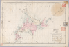
【Courtesy of the C. V. Starr East Asian Library University of California, Berkeley】 Colored manuscript map. Relief shown pictorially. East Asian Library call number: MJ11.
Links: Source / Biblio Ref
|
1874 | about 2 years ago | 15 control points |
|
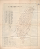
【Courtesy of the C. V. Starr East Asian Library University of California, Berkeley】 Oriented with north to the upper left. In Japanese. Relief shown by hachures. Includes 4 insets and legend. Includes text on districts and distance chart on verso.
Links: Source / Biblio Ref
|
1902 | over 1 year ago | 3 control points |
|
【Courtesy of the C. V. Starr East Asian Library University of California, Berkeley】 Cover title. Title on map: Meiji kaisei Tokyo zenzu. Copperplate print. In Japanese. Oriented with north to the right. Relief shown by hachures. Includes address charts, guide for tourist, time table and legend. Shows views of tourist attractions.
Links: Source / Biblio Ref
|
1888 | over 3 years ago | 4 control points |
|
【Courtesy of the C. V. Starr East Asian Library University of California, Berkeley】 Cover title. Wood block print. In Japanese. Oriented with north to the left. Relief shown pictorially. Includes distance chart and seasonal tides. Folded in envelope 16 x 8 cm. East Asian Library call number: F22.
Links: Source / Biblio Ref
|
1811 | over 3 years ago | 4 control points |
|
【Courtesy of the C. V. Starr East Asian Library University of California, Berkeley】 Mounted cover title. Copperplate print, col. In Japanese. Orientation varies. Relief shown pictorially. Includes 2 insets, list of capitals and legend. Shows distance of roads and sea routes. Folded in cover 19 x 8 cm. East Asian Library call number: J36.
Links: Source / Biblio Ref
|
1884 | over 3 years ago | 5 control points |
|
【Courtesy of the C. V. Starr East Asian Library University of California, Berkeley】 In Japanese. Oriented with north to the left. Relief shown pictorially. Includes distance chart and legend. Includes 1 map on verso.
Links: Source / Biblio Ref
|
1895 | over 3 years ago | 4 control points |
|
【Courtesy of the C. V. Starr East Asian Library University of California, Berkeley】 Copperplate print. In Japanese. Oriented with north to the left. Relief shown pictorially. Includes distance chart, index, and legend.
Links: Source / Biblio Ref
|
1879 | over 3 years ago | 4 control points |
|
【Courtesy of the C. V. Starr East Asian Library University of California, Berkeley】 1 map ; 49 x 69 cm., folded in cover 14 x 20 cm. Cover title. Copperplate print. In Japanese. Oriented with north to the upper right. Relief shown pictorially. Includes views of points of interest, time table, fare table, freight table, railroad company names, and legend. East Asian Library call number: Cb100.
Links: Source / Biblio Ref
|
1888 | over 3 years ago | 5 control points |
|
【Courtesy of the C. V. Starr East Asian Library University of California, Berkeley】 Mounted cover title. Wood block print. In Japanese. Shows distance.
Links: Source / Biblio Ref
|
1751 | over 3 years ago | 4 control points |
|
【Courtesy of the C. V. Starr East Asian Library University of California, Berkeley】 Japanese date Hōei 7 1710. In color. Folded. Wood block print. In Japanese. Relief shown pictorially. Includes distance chart and index.
Links: Source / Biblio Ref
|
1710 | over 3 years ago | 4 control points |
|
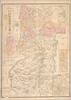
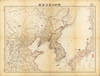
【Courtesy of the C. V. Starr East Asian Library University of California, Berkeley】 1 map : col. ; 46 x 69 cm., folded in cover 25 x 18 cm. Mounted cover title. Wood block print. In Japanese. Covers Honshu to Kyushu. Oriented with north to the upper right. Publication date by the preface. Includes 3 insets: Chosen.--Ryukyu.--Ezo. Shows distance of sea routes. Includes text. East Asian Library call number: Ca 18 SPEC-Map.
Links: Source / Biblio Ref
|
1816 | over 3 years ago | 4 control points |
|
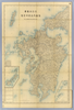
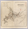
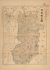
【Courtesy of the C. V. Starr East Asian Library University of California, Berkeley】 Title on envelope :Saishin Nara-ken zenzu. In Japanese. Relief shown by hachures and spot heights. Includes list of addresses and legend.
Links: Source / Biblio Ref
|
1908 | over 3 years ago | 4 control points |
|
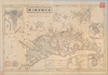
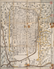
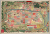
【Courtesy of the C. V. Starr East Asian Library University of California, Berkeley】 Japanese date Meiji 19 1886. In color. Folded. Mounted cover title. Title on map: Kyōto ku kumi meisaizu. Copperplate print. In Japanese. Oriented with north to the left. Relief shown pictorially. Includes distance chart, legend, and index.
Links: Source / Biblio Ref
|
1886 | over 3 years ago | 4 control points |
|
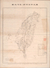
【Courtesy of the C. V. Starr East Asian Library University of California, Berkeley】 1 map : col. ; 43 x 60 cm., folded to 26 x 17 cm. Mounted cover title. In Japanese. Shows distance of sea routes. Includes legend. Relief shown by hachures. East Asian Library call number: Bb 4.
Links: Source / Biblio Ref
|
1904 | over 3 years ago | 4 control points |
|
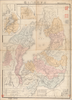
【Courtesy of the C. V. Starr East Asian Library University of California, Berkeley】 1 atlas 2 v. : 76 col. maps ; 26 cm. Wood block print. In Japanese. Preface by Saito Ken and afterword by Yamazaki Giko. Date of publication on preface and afterword. Orientation varies. Covers Matsumae to Tsushima. Engraved by Shogetsudo. Includes Dai Nihon yochi zenzu and Gokai Bunkoku chikyu zenzu. East Asian Library call number: Ca 24.5 Rare-Map.
Links: Source / Biblio Ref
|
1834 | over 3 years ago | 4 control points |
|
【Courtesy of the C. V. Starr East Asian Library University of California, Berkeley】 Cover title. Copperplate print. In Japanese. Orientation varies. Relief shown pictorially. Shows distance of roads and sea routes. Features hand tinted in red, green, and yellow. Includes 2 insets, list of prefectures, and legend. Folded to 19 x 8 cm.
Links: Source / Biblio Ref
|
1895 | over 3 years ago | 4 control points |