Browse Maps
| map | Title | Year | Last Updated | Status  |
|---|---|---|---|---|
|
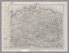
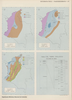
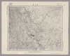
Image from the Map Collections courtesy Stanford University Libraries, licensed under a Creative Commons Attribution-Noncommercial 3.0 Unported License. © Stanford University. 【図幅名】 耶馬溪 【測量時期】 明治36年測圖/昭和7年要部修正測圖 【発行時期】 【記号】 中津十六号 【測量機関】 参謀本部 【備考】 祕
Links: Source / Biblio Ref
|
about 4 years ago | 4 control points | |
|
|
2023 | about 1 year ago | 7 control points |
|
shelfmark: Maps 62980.14
License: Public Domain
文化5 *多色刷り。刊記「浪華書籍師/藤屋弥兵衛・吉文字屋市左衛門」。外題「大日本細見指全図(改正増選)」。 Xylograph.
Links: Source / Biblio Ref
|
1808 | over 3 years ago | 25 control points |
|
|
2022 | almost 2 years ago | 5 control points |
|
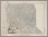
Image from the Map Collections courtesy Stanford University Libraries, licensed under a Creative Commons Attribution-Noncommercial 3.0 Unported License. © Stanford University. 【図幅名】 桜谷 【測量時期】 明治40年測図/昭和8年修正 【発行時期】 昭和11年9月発行 【記号】 剣山10号(共11面) 【測量機関】 大日本帝国陸地測量部 【備考】
Links: Source / Biblio Ref
|
about 2 years ago | 4 control points | |
|
|
2023 | about 1 year ago | 8 control points |
|
shelfmark: Maps 149.e.221
License: Public Domain
江戸後期写 *寛政6序刊図写。 Manuscript, early 19th century. Acquired 22 July 1868. Ex-Siebold. Copy of a map published in 1794.
Links: Source / Biblio Ref
|
about 3 years ago | 15 control points | |
|
shelfmark: Maps 62980.42
License: Public Domain
嘉永7 *多色刷り。「整軒玄魚図書」。外袋に「安政年製/。。。/文溪堂.文昇堂合梓」 Xylograph. Acquired 13 July 1903.
Links: Source / Biblio Ref
|
1854 | over 3 years ago | 23 control points |
|
Image from the Map Collections courtesy Stanford University Libraries, licensed under a Creative Commons Attribution-Noncommercial 3.0 Unported License. © Stanford University. 【図幅名】 新居浜 【測量時期】 明治39年測図/昭和3年修正/昭和8年部分修正 【発行時期】 昭和10年11月発行 【記号】 高知9号(共16面) 【測量機関】 大日本帝国陸地測量部 【備考】 (In 1 layer)
Links: Source / Biblio Ref
|
about 2 years ago | 4 control points | |
|
|
2023 | about 1 year ago | 10 control points |
|
Public Domain. © Stanford University. 【図幅名】 松山北部 【記号】松山近傍7号(共12面)
Links: Source / Biblio Ref
|
about 1 month ago | 4 control points | |
|
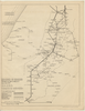
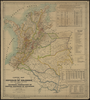
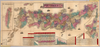
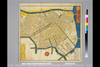
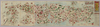
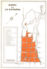
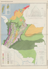
El “Mapa de las líneas marítimas”, un plegable que Julio Parga Polanía incluyó en su Guía del comercio de Bogotá, publicada en 1904 por la Imprenta de El Nuevo Tiempo. El autor se destacó por dirigir una variada colección de publicación de vocación comerciales, entre guías de ciudades de Colombia y publicaciones periodísticas como El Pabellón y El Ciclón. El mapa traza parte de la costa atlántica colombiana, desde Cartagena hasta la península de La Guajira, centrando su interés en Puerto Colombia, renovada terminal marítima de Barranquilla inaugurada en 1893. En tal sentido el documento tuvo la intención de persuadir al lector de la guía para enseñar las posibilidades de transporte marítimo. A través de 11 rutas que conectaron al muelle con distintos puertos de la Europa Occidental, de las Antillas, de México y de E.E.U.U.
Links: Source / Biblio Ref
|
2020 | almost 4 years ago | 4 control points |
|
|
2022 | almost 2 years ago | 10 control points |
|
|
2020 | over 3 years ago | 6 control points |
|
|
2024 | about 1 month ago | 5 control points |
|
shelfmark: Maps 145.d.279
License: Public Domain
嘉永3 *多色刷り。『江戸切絵図集成』第四巻所収の嘉永3訂・図に該当。外題「駿河台小川町絵図」。初版図の刊年が嘉永3となっているが、本図の刊記は「嘉永二己酉年新刻/安政七庚申年改」。英数字・片仮名書き入れ多し。 Xylograph. Acquired 22 July 1868. Ex-Siebold. Edo kiriezu shusei 4: 40-45
Links: Source / Biblio Ref
|
1850 | almost 4 years ago | 9 control points |
|
Links: Source / Biblio Ref
|
2020 | over 1 year ago | 12 control points |
|
Image from the Map Collections courtesy Stanford University Libraries, licensed under a Creative Commons Attribution-Noncommercial 3.0 Unported License. © Stanford University. 【図幅名】 西条 【測量時期】 明治39年測図/昭和3年修正/昭和8年部分修正 【発行時期】 昭和11年1月発行 【記号】 高知13号(共16面) 【測量機関】 大日本帝国陸地測量部 【備考】 (In 1 layer)
Links: Source / Biblio Ref
|
4 months ago | 4 control points | |
|
【Courtesy of the C. V. Starr East Asian Library University of California, Berkeley】 Japanese date Meiji 8 1875. In color. Folded. Mounted cover title. Wood block print. In Japanese. Relief shown by hachures. Orientation varies. 1 inset: Ryūkyū Shotō. Shows distance of sea routes. Includes legend.
Links: Source / Biblio Ref
|
1875 | over 3 years ago | 5 control points |
|
【Courtesy of the C. V. Starr East Asian Library University of California, Berkeley】 Japanese date Meiji 31 1898. In color. Folded. Title on map: Dai Nihon meisai ryokō annai. Mounted cover title. Copperplate print. In Japanese. Oriented with north to the upper right. Includes 3 insets: Hokkaidō zenzu ; Dai Nihon Shinryōchi Taiwan no zu ; Tokyo fuzoku Ogasawarajima. Includes list of district names, charts of mountains and rivers, distance chart of railroads, and legend. Shows sea routes with distances.
Links: Source / Biblio Ref
|
1898 | over 3 years ago | 5 control points |
|
立命館大学古地図データベースより引用
|
over 1 year ago | 156 control points | |
|
国立国会図書館デジタルコレクション
インターネット公開(保護期間満了) (In 4 layers)
Links: Source / Biblio Ref
|
1849 | over 2 years ago | 62 control points |
|
|
2023 | about 1 year ago | 8 control points |
|
国立国会図書館デジタルコレクション インターネット公開(保護期間満了) (In 2 layers)
Links: Source / Biblio Ref
|
1853 | almost 4 years ago | 24 control points |
|
【Courtesy of the C. V. Starr East Asian Library University of California, Berkeley】 Japanese date Meiji 33 1900. In color. Folded. Lithograph. In Japanese. Oriented with north to the upper right. Relief shown by hachures. Includes 5 insets: Hokkaidō zenzu.--Nihon shinryōchi Taiwan zenzu.--Chōsen zenzu ... et al. Includes list of district names, distance chart, and legend. Includes charts of mountains, rivers and lakes. Includes distances of roads and sea routes.
Links: Source / Biblio Ref
|
1900 | over 3 years ago | 5 control points |
|
|
2020 | almost 4 years ago | 5 control points |
|
【Courtesy of the C. V. Starr East Asian Library University of California, Berkeley】 Wood block print. In Japanese. Covers Ezo to a part of Ryūkyū. Includes distance chart and legend. Engraved by Nakazawa Hachibē. Folded to 19 x 9 cm.
Links: Source / Biblio Ref
|
1863 | over 3 years ago | 4 control points |
|
Links: Source / Biblio Ref
|
2020 | almost 3 years ago | 3 control points |
|
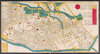
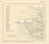
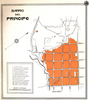
Plan de Fès Djedid levé par le Lieutenant Ortholieb du 4e régiment de Tirailleurs
Janvier, Mars 1913
|
1913 | over 3 years ago | 6 control points |
|
国立国会図書館デジタルコレクション インターネット公開(保護期間満了) (In 2 layers)
Links: Source / Biblio Ref
|
1853 | almost 4 years ago | 54 control points |
|
国立国会図書館デジタルコレクション インターネット公開(保護期間満了) (In 3 layers)
Links: Source / Biblio Ref
|
1850 | almost 4 years ago | 33 control points |
|
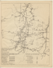
【Courtesy of the C. V. Starr East Asian Library University of California, Berkeley】 In Japanese and English. Oriented with north to the upper right. Relief shown by hachures and spot heights. Watersheds and major streams delineated. Existing and projected railroads in red. Includes two insets, preface and legend. Includes list of railway tracks pasted to map. Folded to 30 x 21 cm.
Links: Source / Biblio Ref
|
1894 | over 3 years ago | 5 control points |
|
【Courtesy of the C. V. Starr East Asian Library University of California, Berkeley】 Title on map: Kaisei shinkoku Dai Nihon dōchūki. Copperplate print. In Japanese. Orientation varies. Relief shown pictorially. Features hand tinted in orange, yellow, pink, red and green. Includes 2 insets, list of shrines and legend. Shows distances of roads and sea routes. Folded to 19 x 10 cm.
Links: Source / Biblio Ref
|
1884 | over 3 years ago | 5 control points |
|
|
2023 | about 1 year ago | 5 control points |
|
(In 1 layer)
|
2020 | almost 4 years ago | 5 control points |
|
【Courtesy of the C. V. Starr East Asian Library University of California, Berkeley】 1 map : col. ; 145 x 130 cm., folded in cover 40 x 24 cm. Mounted cover title. Copperplate print. In Japanese. Relief shown by hachures. Includes 3 insets and legend. East Asian Library call number Cb 2.
Links: Source / Biblio Ref
|
1871 | over 3 years ago | 5 control points |
|
Links: Source / Biblio Ref
|
2020 | almost 3 years ago | 3 control points |
|
【Courtesy of the C. V. Starr East Asian Library University of California, Berkeley】 Cover title. Copperplate print. In Japanese. Orientation varies. Relief shown pictorially. Shows distance of roads and sea routes. Features hand tinted in red, green, and yellow. Includes 2 insets, list of prefectures, and legend. Folded to 19 x 8 cm.
Links: Source / Biblio Ref
|
1895 | over 3 years ago | 4 control points |
|
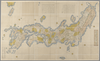
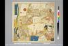
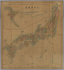
【Courtesy of the C. V. Starr East Asian Library University of California, Berkeley】 1 atlas 2 v. : 76 col. maps ; 26 cm. Wood block print. In Japanese. Preface by Saito Ken and afterword by Yamazaki Giko. Date of publication on preface and afterword. Orientation varies. Covers Matsumae to Tsushima. Engraved by Shogetsudo. Includes Dai Nihon yochi zenzu and Gokai Bunkoku chikyu zenzu. East Asian Library call number: Ca 24.5 Rare-Map.
Links: Source / Biblio Ref
|
1834 | over 3 years ago | 4 control points |
|
(In 1 layer)
|
2020 | almost 4 years ago | 8 control points |
|
|
2020 | almost 4 years ago | 3 control points |
|
【Courtesy of the C. V. Starr East Asian Library University of California, Berkeley】 1 map : col. ; on sheet 85 x 113 cm., folded in cover 29 x 17 cm. Mounted cover title. Wood block print. Oriented with north toward the upper right. In Japanese. Engraved by Hata Kyube. Covers Matsumae to Tanegashima, Yakushima, and Tsushima. Shows longitude and latitude and sea routes with distances. Includes texts on Kuroshio and tides. Includes preface by Shibano Ritsuzan and legend. East Asian Library call number Ca 14.
Links: Source / Biblio Ref
|
1791 | over 3 years ago | 5 control points |
|
|
2020 | almost 4 years ago | 4 control points |
|
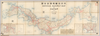
Image from the Map Collections courtesy Stanford University Libraries, licensed under a Creative Commons Attribution-Noncommercial 3.0 Unported License. © Stanford University. 【図幅名】 駿河大宮 【測量時期】 明治20年測図/昭和3年第2回修正 【発行時期】 昭和5年5月発行 【記号】 静岡5号(共15面) 【測量機関】 大日本帝国陸地測量部 【備考】
Links: Source / Biblio Ref
|
about 2 years ago | 4 control points | |
|
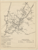
明治20年、早島町大橋家蔵
|
1887 | 20 days ago | 3 control points |
|
国立国会図書館デジタルコレクション インターネット公開(保護期間満了) (In 3 layers)
Links: Source / Biblio Ref
|
1850 | almost 4 years ago | 26 control points |
|
(In 1 layer)
|
2020 | almost 4 years ago | 10 control points |
|
Image from the Map Collections courtesy Stanford University Libraries, licensed under a Creative Commons Attribution-Noncommercial 3.0 Unported License. © Stanford University. 【図幅名】 川島 【測量時期】 明治29年測図/大正6年測図の縮図/昭和9年第2回修正、測図の縮図 【発行時期】 【記号】 徳島12号(共14面) 【測量機関】 参謀本部 【備考】 秘
Links: Source / Biblio Ref
|
about 2 years ago | 4 control points | |
|
Links: Source / Biblio Ref
|
2020 | over 1 year ago | 7 control points |